 Stars4Water
Simulated weather data at high resolution for West-Africa 2000-2009 - ClimAfrica WP2
The whole set of simulated data contains over 400 Gb (hourly data for 10 years) after conversion to ASCII format.
Warning: These "data" are not based on reanalysis of observations, but just on modeling with initial and boundary conditions from CMCC-CPS output. The high resolution modeling is an experiment. Especially the calculated precipitation may have systematic deviations from the observations. The purpose of these synthetic data is to test the merit or lack of merit of high-resolution modeling.
The model grid is not aligned with latitude and longitude, so interpolation of the data may be necessary. The output is stored in separate files for each grid.
Data content:
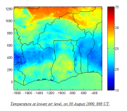
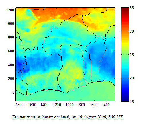
1.Temperature at 20 m (°C);
2. Specific humidity at 20 m (g/kg);
3. Wind speed at 20 m;
4. Wind direction at 20 m;
5. Short wave radiation (W/m2);
6. Sensible heat flux (W/m2);
7. Latent heat flux (W/m2, can be converted directly to evaporation in mm/h);
8. Cumulated precipitation (mm);
Data storage: presently the data are stored in binary files. For each month there are 4 files: one file per ½ calender month - grid - combination. After conversion to text format, the size is about 2.5 Mb (outer grid) or almost 2 Mb (inner grid) for each simulated hour. The size of the whole set converted to ASCII is over 400 Gb.
The simulated weather data or data-excerpts can be made available on demand only. Please contact Antoon Meesters at a.g.c.a.meesters@vu.nl to place your request.
This data model has been produced in the framework of the "Climate change predictions in Sub-Saharan Africa: impacts and adaptations (ClimAfrica)" project, Work Package 2 (WP2). More information on ClimAfrica project is provided in the Supplemental Information section of this metadata.
Simple
- Date (Publication)
- 2014-06-01
- Edition
-
First
- Presentation form
- Digital map
- Purpose
-
WP2 (Modelling seasonal to decadal climate predictions) focused on SSA climate predictability and on the improvement of climate prediction models by virtue of developments in their land surface initialization/representation. The improvement of the prediction of climate over SSA is considered from the perspective of both the large-global scale (i.e.: global coupled climate dynamics modelling) and the small-local scale (i.e.: mesoscale and statistical modelling/downscaling).
Seasonal retrospective forecast for 22 years (1989-2010). Four six-month-forecasts per year, start dates 1st Feb, 1st May, 1st Aug, 1st Nov.
Decadal predictions.
Twenty-year-simulations, start dates 1990-1995-2000-2005-2010, November 1st. Simulations were performed by means of a global climate model initialized with the best observational products of ocean, land and atmosphere.
Outputs provided:
- Surface temperature;
- Precipitation;
- Heat fluxes;
- Winds, etc.
- Status
- Completed
- Maintenance and update frequency
- As needed
- Theme
-
-
weather
-
high-resolution modeling
-
climate prediction models
-
FAO
-
CMCC
-
WP2
-
ClimAfrica
-
Tag_climafrica
-
- Place
-
-
Africa
-
Western Africa
-
- Access constraints
- Copyright
- Spatial representation type
- Grid
- Metadata language
- English
- Character set
- UTF8
- Topic category
-
- Climatology, meteorology, atmosphere
- Begin date
- 2000-02-01
- End date
- 2010-01-31
))
- Supplemental Information
-
ClimAfrica was an international project funded by European Commission under the 7th Framework Programme (FP7) for the period 2010-2014. The ClimAfrica consortium was formed by 18 institutions, 9 from Europe, 8 from Africa, and the Food and Agriculture Organization of United Nations (FAO).
ClimAfrica was conceived to respond to the urgent international need for the most appropriate and up-to-date tools and methodologies to better understand and predict climate change, assess its impact on African ecosystems and population, and develop the correct adaptation strategies. Africa is probably the most vulnerable continent to climate change and climate variability and shows diverse range of agro-ecological and geographical features. Thus the impacts of climate change can be very high and can greatly differ across the continent, and even within countries.
The project focused on the following specific objectives:
1. Develop improved climate predictions on seasonal to decadal climatic scales, especially relevant to SSA;
2. Assess climate impacts in key sectors of SSA livelihood and economy, especially water resources and agriculture;
3. Evaluate the vulnerability of ecosystems and civil population to inter-annual variations and longer trends (10 years) in climate;
4. Suggest and analyse new suited adaptation strategies, focused on local needs;
5 Develop a new concept of 10 years monitoring and forecasting warning system, useful for food security, risk management and civil protection in SSA;
6. Analyse the economic impacts of climate change on agriculture and water resources in SSA and the cost-effectiveness of potential adaptation measures.
The work of ClimAfrica project was broken down into the following work packages (WPs) closely connected. All the activities described in WP1, WP2, WP3, WP4, WP5 consider the domain of the entire South Sahara Africa region. Only WP6 has a country specific (watershed) spatial scale where models validation and detailed processes analysis are carried out.
- Number of dimensions
- 2
- Dimension name
- Column
- Dimension size
- 240
- Resolution
- 25 Km
- Dimension name
- Row
- Dimension size
- 200
- Resolution
- 25 Km
- Cell geometry
- Area
- Transformation parameter availability
- No
- Number of dimensions
- 2
- Dimension name
- Column
- Dimension size
- 191
- Resolution
- 8 Km
- Dimension name
- Row
- Dimension size
- 164
- Resolution
- 8 Km
- Cell geometry
- Point
- Transformation parameter availability
- No
- Distribution format
-
-
ASCII format
(
)
-
ASCII format
(
)
- OnLine resource
- Scenarios of major production systems in Africa ( WWW:LINK-1.0-http--link )
- Units of distribution
-
GB
- Transfer size
- 400
- OnLine resource
- Climafrica Website - Climate Change Predictions In Sub-Saharan Africa: Impacts And Adaptations ( WWW:LINK-1.0-http--link )
- Hierarchy level
- Model
- Statement
-
Technical details concerning the computation:
Calculations used the RAMS model. The results for the two grids were calculated simultaneously (two way nested grid approach).
An outer and an inner grid are used. At the location of the inner grid, calculations are carried out for both grids, with a two-way traffic of data between the two (as always in RAMS).
Radiation scheme: Chen & Cotton scheme (a Harrington scheme, incorporates division between water clouds and ice clouds, is also available but works slower).
Precipitation:
1 -The microphysics scheme of RAMS is applied with standard settings; except that the shape parameter for the gamma-distribution ("GNU") has been increased to 6.
2 - No use is made of the option to carry out a correction (convective adaptation) for unresolved convection. With this correction, the precipitation is strongly amplified, as has been corroborated by tests.
- File identifier
- 09bcea09-c3c8-40af-b428-02bbbb2bcc50 XML
- Metadata language
- English
- Character set
- UTF8
- Date stamp
- 2023-01-25T09:33:22
- Metadata standard name
-
ISO 19115:2003/19139
- Metadata standard version
-
1.0
Overviews
Spatial extent
Provided by
