 Stars4Water
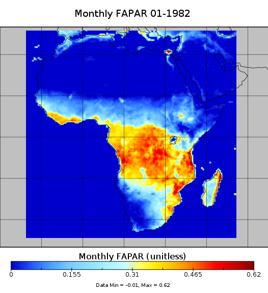
A consistent 28 year record of FAPAR - ClimAfrica WP1
A consistent and harmonized product of satellite observed fraction of absorbed photosynthetically active radiation (FAPAR). FAPAR is a biophysical variable that indicates the state and health of the vegetation. This data set provides monthly FAPAR from 1982 until 2010 at global scale and for the African continent. The construction of the data set made use of existing products from AVHRR, SeaWiFS and MERIS satellite sensors.
This data set has been produced in the framework of the "Climate change predictions in Sub-Saharan Africa: impacts and adaptations (ClimAfrica)" project, Work Package 1 (WP1).
WP1 (Past climate variability) aimed to provide consolidated data to other WPs in ClimAfrica, and to analyze the interactions between climate variability, water availability and ecosystem productivity of Sub-Saharan Africa. Various data streams that diagnose the variability of the climate, in particular the water cycle, and the productivity of ecosystems in the past decades, have been collected, analyzed and synthesized. The data streams range from ground-based observations and satellite remote sensing to model simulations. More information on ClimAfrica project is provided in the Supplemental Information section of this metadata.
Simple
- Date (Publication)
- 2014-05-15T11:22:00
- Edition
-
First
- Presentation form
- Digital map
- Purpose
-
The FAPAR record is a central ingredient for the synthesis analysis in WP1, including the data-driven estimates of carbon and water fluxes. Moreover, it will be used to evaluate the simulations of impact models (WP3) and to initialize GCM simulations to improve seasonal and decadal forecasts (WP2).
- Status
- On going
- Maintenance and update frequency
- As needed
- Theme
-
-
satellite image
-
photosynthetic active radiation
-
FAPAR
-
WP1
-
ClimAfrica
-
Tag_climafrica
-
- Place
-
-
Africa
-
- Place
-
-
World
-
- Access constraints
- Restricted
- Use constraints
- Copyright
- Other constraints
-
Please contact the data originator to get info on data access and use
- Spatial representation type
- Grid
- Distance
- 0.5 Degree
- Metadata language
- English
- Character set
- UTF8
- Topic category
-
- Imagery base maps earth cover
- Begin date
- 1982-01-01
- End date
- 2010-12-31
))
- Supplemental Information
-
ClimAfrica was an international project funded by European Commission under the 7th Framework Programme (FP7) for the period 2010-2014. The ClimAfrica consortium was formed by 18 institutions, 9 from Europe, 8 from Africa, and the Food and Agriculture Organization of United Nations (FAO).
ClimAfrica was conceived to respond to the urgent international need for the most appropriate and up-to-date tools and methodologies to better understand and predict climate change, assess its impact on African ecosystems and population, and develop the correct adaptation strategies. Africa is probably the most vulnerable continent to climate change and climate variability and shows diverse range of agro-ecological and geographical features. Thus the impacts of climate change can be very high and can greatly differ across the continent, and even within countries.
The project focused on the following specific objectives:
1. Develop improved climate predictions on seasonal to decadal climatic scales, especially relevant to SSA;
2. Assess climate impacts in key sectors of SSA livelihood and economy, especially water resources and agriculture;
3. Evaluate the vulnerability of ecosystems and civil population to inter-annual variations and longer trends (10 years) in climate;
4. Suggest and analyse new suited adaptation strategies, focused on local needs;
5 Develop a new concept of 10 years monitoring and forecasting warning system, useful for food security, risk management and civil protection in SSA;
6. Analyse the economic impacts of climate change on agriculture and water resources in SSA and the cost-effectiveness of potential adaptation measures.
The work of ClimAfrica project was broken down into the following work packages (WPs) closely connected. All the activities described in WP1, WP2, WP3, WP4, WP5 consider the domain of the entire South Sahara Africa region. Only WP6 has a country specific (watershed) spatial scale where models validation and detailed processes analysis are carried out.
- Reference system identifier
- WGS 1984
- Distribution format
-
-
(
GeoTiff
)
-
(
GeoTiff
)
OnLine resource
- OnLine resource
- Scenarios of major production systems in Africa ( WWW:LINK-1.0-http--link )
- OnLine resource
- CLIMAFRICA – Climate change predictions in Sub-Saharan Africa: impacts and adaptations ( WWW:LINK-1.0-http--link )
- File identifier
- 157a3ef5-0bca-442c-baea-fa530bd888c6 XML
- Metadata language
- English
- Character set
- UTF8
- Date stamp
- 2023-01-24T14:25:04
- Metadata standard name
-
ISO 19115:2003/19139
- Metadata standard version
-
1.0
Overviews

Spatial extent
Provided by
