 Stars4Water
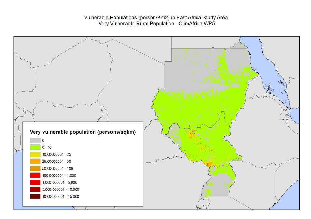
Vulnerable populations (person/km2) in East Africa - ClimAfrica WP5
In defining vulnerability, WFP (2009) and IFPRI (2012) have been followed and combined with indicators for food security with health indicators that signal vulnerability in a physical sense. IFPRI's Global Hunger Index uses three indicators to measure hunger: the number of adults being undernourished, the number of children that have low weight for age, and child mortality. Other classifications of food security use the variety of the diet as an indicator, combined with anthropometric data on children. However, in the DHS data there were no information available on child mortality, nor on dietary composition. Given these data limitations, data on nutritional status of women (Body Mass Index, BMI) for women and children (weight for age) have been used as indicators for food security. These data were combined with data on morbidity among adults and children, specifically the occurrence of malaria, cough, and diarrhea. Combinations of indicators have led to a classification of households as being very vulnerable, vulnerable, nearly vulnerable and not vulnerable. The Afrobarometer surveys did not include data on the BMI of adults nor weights for children. Here, the reported times the household went without food in the year were used prior to the date the survey was conducted as vulnerability indicator. The study area of households vulnerability included: rural, urban and total population.
This data set was produced in the framework of the "Climate change predictions in Sub-Saharan Africa: impacts and adaptations (ClimAfrica)" project, Work Package 5 (WP5). More information on ClimAfrica project is provided in the Supplemental Information section of this metadata.
This study in WP5 aimed to identify, locate and characterize groups that are vulnerable for climate change conditions in two country clusters; one in West Africa (Benin, Burkina Faso, Côte d'Ivoire, Ghana, and Togo) and one in East Africa (Sudan, South Sudan and Uganda). Data used for the study include the Demographic and Health Surveys (DHS) , the Multi Indicator Cluster Survey (MICS) and the Afrobarometer surveys for the socio-economic variables and grid level data on agro-ecological and climatic conditions.
Simple
- Date (Creation)
- 2013-08-01T22:00:00
- Edition
-
First
- Presentation form
- Digital map
- Purpose
-
WP5 deals with economic assessment of agriculture and water sector based on a Computable General Equilibrium analysis (ICES) to produce the "inaction" and the adaptation scenarios, for direct climate change impacts on agricultural activity and on the direct cost and effectiveness of adaptation strategies. The main advantage of this investigation approach is to depict the economy as a system where goods and factor markets interacts domestically and internationally. Price effects, competitiveness effects, and demand & supply adjustments triggered by impacts on the agricultural sector can thus be properly captured. Moreover, the spatially explicit and dynamic economic modeling of vulnerability will have to accommodate bio-physical vulnerabilities.
- Status
- Completed
- Maintenance and update frequency
- As needed
- Theme
-
-
degradation index
-
soil degradation
-
land degradation
-
GLASOD
-
WP5
-
ClimAfrica
-
Tag_climafrica
-
- Place
-
-
Africa
-
Sudan
-
South Sudan
-
Uganda
-
- Access constraints
- Copyright
- Spatial representation type
- Grid
- Distance
- 10 Km
- Metadata language
- English
- Character set
- UTF8
- Topic category
-
- Society
- Health
))
- Supplemental Information
-
ClimAfrica was an international project funded by European Commission under the 7th Framework Programme (FP7) for the period 2010-2014. The ClimAfrica consortium was formed by 18 institutions, 9 from Europe, 8 from Africa, and the Food and Agriculture Organization of United Nations (FAO).
ClimAfrica was conceived to respond to the urgent international need for the most appropriate and up-to-date tools and methodologies to better understand and predict climate change, assess its impact on African ecosystems and population, and develop the correct adaptation strategies. Africa is probably the most vulnerable continent to climate change and climate variability and shows diverse range of agro-ecological and geographical features. Thus the impacts of climate change can be very high and can greatly differ across the continent, and even within countries.
The project focused on the following specific objectives:
1. Develop improved climate predictions on seasonal to decadal climatic scales, especially relevant to SSA;
2. Assess climate impacts in key sectors of SSA livelihood and economy, especially water resources and agriculture;
3. Evaluate the vulnerability of ecosystems and civil population to inter-annual variations and longer trends (10 years) in climate;
4. Suggest and analyse new suited adaptation strategies, focused on local needs;
5. Develop a new concept of 10 years monitoring and forecasting warning system, useful for food security, risk management and civil protection in SSA;
6. Analyse the economic impacts of climate change on agriculture and water resources in SSA and the cost-effectiveness of potential adaptation measures.
The work of ClimAfrica project was broken down into the following work packages (WPs) closely connected. All the activities described in WP1, WP2, WP3, WP4, WP5 consider the domain of the entire South Sahara Africa region. Only WP6 has a country specific (watershed) spatial scale where models validation and detailed processes analysis are carried out.
- Reference system identifier
- WGS 1984
- Distribution format
-
-
ASCII format
(
)
-
ASCII format
(
)
- OnLine resource
-
VVRUE.zip
(
WWW:DOWNLOAD-1.0-http--download
)
Very vulnerable rural population, persons/km2
- OnLine resource
-
VRURE.zip
(
WWW:DOWNLOAD-1.0-http--download
)
Vulnerable rural population, persons/km2
- OnLine resource
-
BVRUE.zip
(
WWW:DOWNLOAD-1.0-http--download
)
Nearly vulnerable rural population, persons/km2
- OnLine resource
-
NVRUE.zip
(
WWW:DOWNLOAD-1.0-http--download
)
Not vulnerable rural population, persons/km2
- OnLine resource
-
VVURBE.zip
(
WWW:DOWNLOAD-1.0-http--download
)
Very vulnerable urban population, persons/km2
- OnLine resource
-
VURBE.zip
(
WWW:DOWNLOAD-1.0-http--download
)
Vulnerable urban population, persons/km2
- OnLine resource
-
BVURE.zip
(
WWW:DOWNLOAD-1.0-http--download
)
Nearly vulnerable urban population, persons/km2
- OnLine resource
-
VVTOTE.zip
(
WWW:DOWNLOAD-1.0-http--download
)
Very vulnerable population, persons/km2
- OnLine resource
-
VTOTAE.zip
(
WWW:DOWNLOAD-1.0-http--download
)
Vulnerable population, persons/km2
- OnLine resource
-
BVTOTE.zip
(
WWW:DOWNLOAD-1.0-http--download
)
Nearly vulnerable population, persons/km2
- OnLine resource
-
D_5.2.1.pdf
(
WWW:DOWNLOAD-1.0-http--download
)
A spatially explicit assessment of specific vulnerabilities of the food system due to climate change and the identification of their causes; Technical report
- OnLine resource
- Scenarios of major production systems in Africa ( WWW:LINK-1.0-http--link )
- OnLine resource
- CLIMAFRICA – Climate change predictions in Sub-Saharan Africa: impacts and adaptations ( WWW:LINK-1.0-http--link )
- File identifier
- 18ab4c59-1836-4b7b-8b7f-99872b326c73 XML
- Metadata language
- English
- Character set
- UTF8
- Date stamp
- 2023-01-31T12:33:30
- Metadata standard name
-
ISO 19115:2003/19139
- Metadata standard version
-
1.0
Overviews

Spatial extent
Provided by
