 Stars4Water
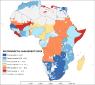
Environmental management index (2010) - ClimAfrica WP4
The “environmental management index” symbolize the impacts of institutional management on ecosystem and thus the ability of state institution to enhance the resilience to environmental and climate change in 2010. Institution able to manage efficiently the biodiversity and habitat conservation and to administer water related problems may have the capacity to face the impact of climate change on agriculture and water resources. Moreover ecosystem diversity and conservation is an indicator of environmental health, which maintains environmental services and natural balance among species. These ecological qualities are useful for communities when trying to keep or improve adaptation processes. The index results from the third cluster of the Principal Component Analysis preformed among 18 potential variables. The analysis identifies two dominant variables, namely “habitat and biodiversity management” and “water management”, assigning weights of 0.6 and 0.4, respectively. Before to perform the analysis the variables were log transformed to shorten the extreme variation and then were score-standardized (converted to distribution with average of 0 and standard deviation of 1) in order to be comparable. The country based values of the two variables were obtained from sub-indicators of the Environmental Performance Index (EPI) developed by Yale University. The “habitat and biodiversity management” includes four indicators: Critical Habitat Protection, Terrestrial Protected Areas (National Biome Weight), Terrestrial Protected Areas (Global Biome Weight), and Marine Protected Areas, whereas the “water management” include the only Wastewater treatment indicator. The data represents the averaged value for the period 2008-2012. EPI indicators use a “proximity-to-target” methodology, which assesses how close a particular country is to an identified policy target. Thus, scores are on a scale of 0 to 100 by simple arithmetic calculation, with 0 being the farthest from the target and 100 being closest to the target.
This dataset has been produced in the framework of the “Climate change predictions in Sub-Saharan Africa: impacts and adaptations (ClimAfrica)” project, Work Package 4 (WP4). More information on ClimAfrica project is provided in the Supplemental Information section of this metadata.
Simple
- Date (Creation)
- 2014-09-01T00:00:00
- Presentation form
- Digital map
- Purpose
-
Purpose of WP4 - D4.3 is to establish a medium-term warning system (based on ClimAfrica data) that produces prospective analyses about climate change impacts on agriculture for the next 10 years. This will fill the gap between seasonal scale predictions and long-term impact scenarios, and identify the future Areas of Concerns (AoCs) and likely hotspots of vulnerabilities.
- Status
- Completed
- Maintenance and update frequency
- As needed
- Theme
-
-
habitat
-
biodiversity and water management
-
adaptive capacity
-
WP4
-
ClimAfrica
-
Tag_climafrica
-
- Place
-
-
Africa
-
- Access constraints
- Copyright
- Spatial representation type
- Grid
- Distance
- 30 arc/sec
- Metadata language
- English
- Character set
- UTF8
- Topic category
-
- Society
))
- Supplemental Information
-
ClimAfrica was an international project funded by European Commission under the 7th Framework Programme (FP7) for the period 2010-2014. The ClimAfrica consortium was formed by 18 institutions, 9 from Europe, 8 from Africa, and the Food and Agriculture Organization of United Nations (FAO).
ClimAfrica was conceived to respond to the urgent international need for the most appropriate and up-to-date tools and methodologies to better understand and predict climate change, assess its impact on African ecosystems and population, and develop the correct adaptation strategies. Africa is probably the most vulnerable continent to climate change and climate variability and shows diverse range of agro-ecological and geographical features. Thus the impacts of climate change can be very high and can greatly differ across the continent, and even within countries.
The project focused on the following specific objectives:
1. Develop improved climate predictions on seasonal to decadal climatic scales, especially relevant to SSA;
2. Assess climate impacts in key sectors of SSA livelihood and economy, especially water resources and agriculture;
3. Evaluate the vulnerability of ecosystems and civil population to inter-annual variations and longer trends (10 years) in climate;
4. Suggest and analyse new suited adaptation strategies, focused on local needs;
5 Develop a new concept of 10 years monitoring and forecasting warning system, useful for food security, risk management and civil protection in SSA;
6. Analyse the economic impacts of climate change on agriculture and water resources in SSA and the cost-effectiveness of potential adaptation measures.
The work of ClimAfrica project was broken down into the following work packages (WPs) closely connected. All the activities described in WP1, WP2, WP3, WP4, WP5 consider the domain of the entire South Sahara Africa region. Only WP6 has a country specific (watershed) spatial scale where models validation and detailed processes analysis are carried out.
- Reference system identifier
- GCS WGS 84 (EPSG Ellipsoid 7030)
- Distribution format
-
-
(
GeoTiff
)
-
(
GeoTiff
)
- OnLine resource
-
ClimAfr28_Environmental_management_index.zip
(
WWW:DOWNLOAD-1.0-http--download
)
Environmental management index (2010)
- OnLine resource
-
geonetwork:climafr28_env_management_index_48386
(
OGC:WMS-1.1.1-http-get-map
)
Environmental management index (2010)
- OnLine resource
-
Scenarios of major production systems in Africa
(
WWW:LINK-1.0-http--link
)
Project deliverable D4.1 - Scenarios of major production systems in Africa
- OnLine resource
-
CLIMAFRICA – Climate change predictions in Sub-Saharan Africa: impacts and adaptations
(
WWW:LINK-1.0-http--link
)
Climafrica Website - Climate Change Predictions In Sub-Saharan Africa: Impacts And Adaptations
- File identifier
- 35c65a15-5e18-4699-893b-d0fb02da38d1 XML
- Metadata language
- English
- Character set
- UTF8
- Date stamp
- 2023-01-24T08:48:12
- Metadata standard name
-
ISO 19115:2003/19139
- Metadata standard version
-
1.0
Overviews

Spatial extent
Provided by
