 Stars4Water
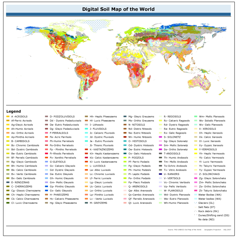
Digital Soil Map of the World
The vector data set is based on the FAO-UNESCO Soil Map of the World. The Digitized Soil Map of the World, at 1:5.000.000 scale, is in the Geographic projection (Latitude - Longitude) intersected with a template containing water related features (coastlines, lakes, glaciers and double-lined rivers). The Digital Soil Map of the World (except for the continent of Africa) was intersected with the Country Boundaries map from the World Data Bank II (with country boundaries updated to January 1994 at 1:3 000 000 scale), obtained from the US Government. For Africa, the country boundaries are derived from the FAO Country Boundaries on the original FAO/UNESCO Soil Map of the World. Country boundaries in both cases were checked and adjusted in certain places on the basis of FAO and UN conventions.
The maps (jpg and pdf) are also available on the FAO soil Portal together with their reports for the following regions : North America, Mexico and Central America, South America, Europe, Asia, South Asia, Nortah and Central Asia, Sourtheast Asia and Australasia.
Simple
- Date (Revision)
- 2007-02-28
- Edition
-
version 3.6
- Presentation form
- Digital map
- Purpose
-
Harmonized soil information.
- Status
- Completed
- Maintenance and update frequency
- As needed
- Theme
-
-
soil
-
dominant soil
-
Terrastat
-
DSMW
-
Tag_soil
-
- Place
-
-
World
-
- Access constraints
- Copyright
- Use constraints
- Copyright
- Spatial representation type
- Vector
- Metadata language
-
eng
- Character set
- UTF8
- Topic category
-
- Geoscientific information
))
- Supplemental Information
-
Pertinent information regarding the production and use of the digital soil map of the world can be found in the readme.doc contained in the zip file available below for download. A layer (.lyr), legend (.avl), readme and various excel files desribing the Digital Soil Map of the World are provided in the data download and are described fully at http://www.fao.org/landandwater/agll/key2soil.stm .
Derived soil properties of the Digital Soil Map of the World are also available on GeoNetwork ( http://www.fao.org/geonetwork/ ) by searching the FAO catalogue for "digital soil map of the world".
The Digital Soil Map of the World is also available in raster version (resolution grid: 5 arc minutes).
- Reference system identifier
- WGS 1984
- Topology level
- Abstract
- Geometric object type
- Complex
- Distribution format
-
-
ESRI Shapefile
(
1.0
)
-
ESRI Shapefile
(
1.0
)
- OnLine resource
-
SoilMap_hires.zip
(
WWW:DOWNLOAD-1.0-http--download
)
Digital Soil Map of the World - high resolution map (PDF format - 28MB)
- OnLine resource
- dsmw_14116 ( OGC:WMS-1.1.1-http-get-map )
- OnLine resource
-
DSMW.zip
(
WWW:DOWNLOAD-1.0-http--download
)
Digital Soil Map of the World - ESRI shapefile format
- OnLine resource
-
ERDAS_World.ZIP
(
WWW:DOWNLOAD-1.0-http--download
)
Digital Soil Map of the World - Erdas format
- OnLine resource
-
ERDAS_Regions.zip
(
WWW:DOWNLOAD-1.0-http--download
)
Digital Soil Map of the World (by Regions) - Erdas format
- OnLine resource
-
IDRISI.zip
(
WWW:DOWNLOAD-1.0-http--download
)
Digital Soil Map of the World - IDRISI format
- OnLine resource
- Harmonized World Soil Database ( WWW:LINK-1.0-http--link )
- OnLine resource
- FAO Soils Portal: FAO/UNESCO Soil Map of the World ( WWW:LINK-1.0-http--link )
- Hierarchy level
- Dataset
- File identifier
- 446ed430-8383-11db-b9b2-000d939bc5d8 XML
- Metadata language
-
eng
- Character set
- UTF8
- Date stamp
- 2025-08-11T08:53:10
- Metadata standard name
-
ISO 19115:2003/19139
- Metadata standard version
-
1.0
Overviews

Spatial extent
Provided by
