 Stars4Water
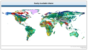
Easily available water
The raster dataset of easily available water has a spatial resolution of 5 * 5 arc minutes and is in geographic projection. Information with regard to available water was obtained from the "Derived Soil Properties" of the FAO-UNESCO Soil Map of the World which contains raster information on soil properties.
Simple
- Date (Publication)
- 2007-02-13
- Edition
-
3.6
- Presentation form
- Digital map
- Purpose
-
This database will be used mainly for poverty and food insecurity mapping, particularly for analysing where the people live at global scales in relation to:
- Agroecological zones
- Marginal or productive lands
- Major foodcrop production systems, in particular those important to food security for the rural poor.
- Status
- Completed
- Maintenance and update frequency
- As needed
- Theme
-
-
water
-
soil
-
moisture
-
DSMW
-
Digital Soil Map of the World
-
Tag_AQUASTAT
-
- Place
-
-
World
-
- Access constraints
- Copyright
- Spatial representation type
- Grid
- Metadata language
-
eng
- Character set
- UTF8
- Topic category
-
- Inland waters
- Geoscientific information
))
- Supplemental Information
-
This is an indicator for the amount of stored soil moisture readily available to crops. The water retention at 2 bar suction is used to separate easily available water (EAV) from water which is more tightly held at higher suctions and difficult
to abstract, especially from deeper subsoils; and in the use of a conceptual model of effective rooting depth.
The dataset is available for download (below) in both ASCII and ESRI GRID formats. A layer (.lyr) legend (.avl) and excel file are provided in the downloads.
Structure of the attributes
=======================
The first digit indicates the dominant Smax class (60% of the cell). The second digit indicates the associated (40% of the cell) class. When the second number is 0, this indicates that the whole cell is made up by the Smax class indicated by the first number.
Easily available water
--
The classes are:
1: Wetlands
2: > 120 mm/m
3: 100 - 120 mm/m
4: 60 - 100 mm/m
5: 40 - 60 mm/m
6: 20 - 40 mm/m
7: < 20 mm/m
97:Water
99:Glaciers, Rock, Shifting sand, Missing data
- Reference system identifier
- WGS 1984 - Geographic
- Number of dimensions
- 3
- Dimension name
- Row
- Dimension size
- 2160
- Dimension name
- Column
- Dimension size
- 4320
- Dimension name
- Vertical
- Cell geometry
- Area
- Transformation parameter availability
- No
- OnLine resource
- FAO Land Resources - Digital Media Series (20) ( WWW:LINK-1.0-http--link )
- OnLine resource
-
eaw.zip
(
WWW:DOWNLOAD-1.0-http--download
)
Easy available water - ESRI GRID dataset
- OnLine resource
-
eaw_ascii.zip
(
WWW:DOWNLOAD-1.0-http--download
)
Easy available water - ASCII GRID dataset
- Hierarchy level
- Dataset
- File identifier
- 52240900-bb51-11db-ac8b-000d939bc5d8 XML
- Metadata language
-
eng
- Character set
- UTF8
- Date stamp
- 2020-01-09T15:24:37
- Metadata standard name
-
ISO 19115:2003/19139
- Metadata standard version
-
1.0
Overviews

Spatial extent
Provided by
