 Stars4Water
WATCH Meteorological Forcing Data for Africa (WFD) - ClimAfrica WP1
WATCH Forcing Data 20th Century. A meteorological forcing dataset (based on ERA-40) for land surface and hydrological models (1901-2001).
Data generated in 2 tranches with slightly different methodology: 1901-1957 and 1958-2001. Five variables are at 6 hourly resolution and five variables are at 3 hourly resolution:
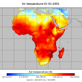
Tair_WFD_ - 2m Air temperature (K)
Tmin_WFD_ - 2m Minimum air temperature (K)
Tmax_WFD_ - 2m Maximum air temperature (K)
PSurf_WFD_ - 10m Surface pressure (Pa)
Qair_WFD_ - 2m Specific umidity (kg/kg)
Wind_WFD_ - 10m Wind speed (m/s)
LWdown_WFD_ - Downwards long-wave radiation flux (W/m-2)
SWdown_WFD_ - Downwards short-wave radiation flux (W/m-2)
Rainf_WFD_GPCC_ - Rainfall rate GPCC bias corrected and undercatch corrected
Snowf_WFD_GPCC_ - Snowfall rate GPCC bias corrected and undercatch corrected (kg/m-2/s)
Rainf_WFD_CRU_ - Rainfall rate CRU bias corrected and undercatch corrected (kg/m-2/s)
Snowf_WFD_CRU_ - Snowfall rate CRU bias corrected and undercatch corrected (kg/m-2/s).
This data set has been produced in the framework of the "Climate change predictions in Sub-Saharan Africa: impacts and adaptations (ClimAfrica)" project, Work Package 1 (WP1).
WP1 (Past climate variability) aimed to provide consolidated data to other WPs in ClimAfrica, and to analyze the interactions between climate variability, water availability and ecosystem productivity of Sub-Saharan Africa. Various data streams that diagnose the variability of the climate, in particular the water cycle, and the productivity of ecosystems in the past decades, have been collected, analyzed and synthesized. The data streams range from ground-based observations and satellite remote sensing to model simulations. More information on ClimAfrica project is provided in the Supplemental Information section of this metadata.
Simple
- Date (Publication)
- 2014-05-15T11:24:00
- Edition
-
First
- Presentation form
- Digital map
- Purpose
-
WATCH data provide policy makers with a consistent and clear assesment of flows, floods and drougths for present and future scenario's.
- Status
- On going
- Maintenance and update frequency
- Daily
- Theme
-
-
meteorology
-
climate
-
air temperature
-
surface pressure
-
specific umidity
-
wind speed
-
long-wave radiation flux
-
short-wave radiation flux
-
rainfall rate
-
snowfall rate
-
GPCC
-
CRU
-
WP1
-
ClimAfrica
-
Tag_climafrica
-
- Place
-
-
Africa
-
- Access constraints
- Restricted
- Use constraints
- Copyright
- Other constraints
-
Please contact the data originator to get info of data access and use
- Spatial representation type
- Grid
- Metadata language
- English
- Character set
- UTF8
- Topic category
-
- Climatology, meteorology, atmosphere
- Begin date
- 1901-01-01
- End date
- 2001-12-31
))
- Supplemental Information
-
The Water and Global Change (WATCH) programme was an Integrated Project funded under the European Union’s Sixth Framework Programme. It ran from February 2007 to July 2011. For the first time it brought together the hydrological, water resources and climate research communities at an international level. Together they analysed, quantified and predicted the components of the global water cycle and the related water resources – for the present and for the future. They also evaluated the associated uncertainties, and clarified the vulnerability of global water resources within key societal and economic sectors.
ClimAfrica was an international project funded by European Commission under the 7th Framework Programme (FP7) for the period 2010-2014. The ClimAfrica consortium was formed by 18 institutions, 9 from Europe, 8 from Africa, and the Food and Agriculture Organization of United Nations (FAO).
ClimAfrica was conceived to respond to the urgent international need for the most appropriate and up-to-date tools and methodologies to better understand and predict climate change, assess its impact on African ecosystems and population, and develop the correct adaptation strategies. Africa is probably the most vulnerable continent to climate change and climate variability and shows diverse range of agro-ecological and geographical features. Thus the impacts of climate change can be very high and can greatly differ across the continent, and even within countries.
The project focused on the following specific objectives:
1. Develop improved climate predictions on seasonal to decadal climatic scales, especially relevant to SSA;
2. Assess climate impacts in key sectors of SSA livelihood and economy, especially water resources and agriculture;
3. Evaluate the vulnerability of ecosystems and civil population to inter-annual variations and longer trends (10 years) in climate;
4. Suggest and analyse new suited adaptation strategies, focused on local needs;
5 Develop a new concept of 10 years monitoring and forecasting warning system, useful for food security, risk management and civil protection in SSA;
6. Analyse the economic impacts of climate change on agriculture and water resources in SSA and the cost-effectiveness of potential adaptation measures.
The work of ClimAfrica project was broken down into the following work packages (WPs) closely connected. All the activities described in WP1, WP2, WP3, WP4, WP5 consider the domain of the entire South Sahara Africa region. Only WP6 has a country specific (watershed) spatial scale where models validation and detailed processes analysis are carried out.
- Reference system identifier
- WGS 1984
- Distribution format
-
-
(
GeoTiff
)
-
(
GeoTiff
)
- OnLine resource
- Scenarios of major production systems in Africa ( WWW:LINK-1.0-http--link )
- OnLine resource
- CLIMAFRICA – Climate change predictions in Sub-Saharan Africa: impacts and adaptations ( WWW:LINK-1.0-http--link )
- OnLine resource
- Researchers provide extensive analysis of the world's water cycle ( WWW:LINK-1.0-http--link )
- File identifier
- 616e5bdb-e583-4941-b2a5-a23d69a6b790 XML
- Metadata language
- English
- Character set
- UTF8
- Date stamp
- 2023-01-24T09:14:54
- Metadata standard name
-
ISO 19115:2003/19139
- Metadata standard version
-
1.0
Overviews

Spatial extent
Provided by
