 Stars4Water
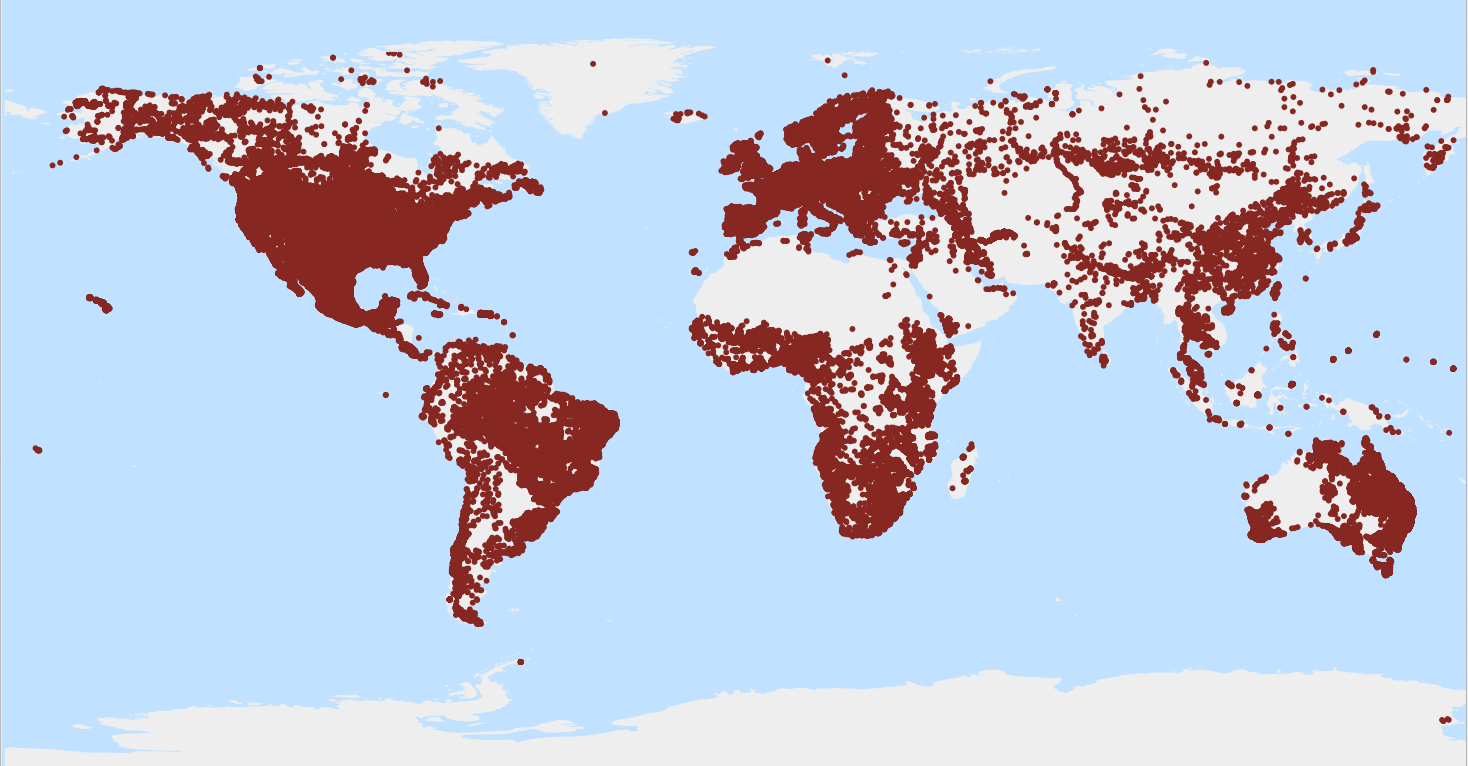
WoSIS latest - Sites
This file provides an overview of the site locations where profiles (or point data) in WoSIS are located. Depending on the type of survey, one or more profiles can occur within a site in accordance with ISO 28528 soil domain conventions.
WoSIS_latest is a 'dynamic dataset' that contains the most recent complement of quality-assessed and standardised soil data served from WoSIS (ISRIC World Soil Information Service). Being dynamic, this dataset will grow/change once new point data are acquired and standardised, additional soil properties are considered, and/or when possible amendments are required.
Static snapshots of wosis_latest are released at irregular intervals for consistent citation purposes, see https://doi.org/10.5194/essd-16-4735-2024 and WoSIS FAQ-page ( https://www.isric.org/explore/wosis/faq-wosis ).
Simple
- Date (Publication)
- 2020-05-01
- Identifier
- 689b490b-5a6b-467e-9d2c-6c205d9a660b
- Presentation form
- Digital map
- Status
- On going
- Theme
-
-
site locations
-
soil profiles
-
-
Stratum
-
-
Soil science
-
-
Region
-
-
Global
-
- Access constraints
- License
- Use constraints
- License
- Other constraints
-
Licenced per profile, as specified by data provider and indicated in the data set
- Spatial representation type
- Vector
- Denominator
- 100000
- Metadata language
- English
- Character set
- UTF8
- Topic category
-
- Geoscientific information
- Begin date
- 1918-01-01
- End date
- 2013-02-12
))
- Reference system identifier
- EPSG / 4326
- Distribution format
-
-
CSV
(
)
-
CSV
(
)
- OnLine resource
-
:wosis_latest_sites
(
OGC:WFS
)
WoSIS latest - Sites
- OnLine resource
- Scientific paper ( WWW:LINK-1.0-http--related )
- OnLine resource
- WoSIS FAQ webpage ( WWW:LINK-1.0-http--related )
- OnLine resource
-
wosis_latest_sites
(
OGC:WMS
)
WoSIS latest - Sites
- OnLine resource
-
Acknowledgement of data providers
(
WWW:LINK-1.0-http--link
)
The development of WoSIS (World Soil Information Service) has been made possible thanks to the contributions and shared knowledge of a steadily growing number of data providers, including soil survey organisations, research institutes and individual experts. We gratefully acknowledge their contributions and look forward to new contributions!
- Hierarchy level
- Dataset
- File identifier
- 689b490b-5a6b-467e-9d2c-6c205d9a660b XML
- Metadata language
- English
- Character set
- UTF8
- Hierarchy level
- Dataset
- Hierarchy level name
-
dataset
- Date stamp
- 2024-11-26T15:33:48
- Metadata standard name
-
ISO 19115:2003/19139
- Metadata standard version
-
2003/Cor.1:2006
Overviews
Spatial extent
Provided by
