 Stars4Water
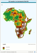
FAO-AquaStat 1 km Hydrologically Filled DEM
WRIA_DEM: Hydrologically filled GTopo30 DEM with the main stems of cartographic rivers "burned-in" for irrigation analysis. GT30/GTopo30 is Global Topographic 30 arc second DEM database, nominal 1km postings; DEM is Digital Elevation Model. The WRIALAEA grid data layer is comprised of 9194x8736 derivative raster hydrologically filled dem features derived based on 1 kilometer data originally from FAO.
Simple
- Date (Creation)
- 15-05-2006
- Edition
-
Second
- Presentation form
- Digital map
- Purpose
-
Modified GTopo30 DEM for irrigation run-off networks
- Status
- Completed
- Maintenance and update frequency
- As needed
- Theme
-
-
hydrologically filled DEM
-
African Water Resource Database
-
AWRD
-
hydrology
-
ancillary raster
-
- Place
-
-
Africa
-
- Access constraints
- Copyright
- Use constraints
- Copyright
- Spatial representation type
- Grid
- Denominator
- 3500000
- Metadata language
-
eng
- Character set
- UTF8
- Topic category
-
- Elevation
- End date
- 2001
))
- Supplemental Information
-
This map is part of two publications entitled:
"Jenness, J.; Dooley, J.; Aguilar-Manjarrez, J.; Riva, C. African Water Resource Database. GIS-based tools for inland aquatic resource management. 1. Concepts and application case studies CIFA Technical Paper. No.33, Part 1. Rome, FAO. 2007. 167p. "
"Jenness, J.; Dooley, J.; Aguilar-Manjarrez, J.; Riva, C. African Water Resource Database. GIS-based tools for inland aquatic resource management. 2. Technical manual and workbook. CIFA Technical Paper. No. 33, Part 2. Rome, FAO. 2007. 308 p."
The primary AWRD interface, tool-sets and data integral to the function of the AWRD are distributed in two DVD's accompanying CIFA No. 33, Part 2, and are also available for download from FAO's GeoNetwork and GISFish GIS portals.
- Number of dimensions
- 2
- Dimension name
- Row
- Dimension size
- 9194
- Resolution
- 1000 METERS,
- Dimension name
- Column
- Dimension size
- 8736
- Resolution
- 1000 METERS,
- Cell geometry
- Area
- Transformation parameter availability
- Units of distribution
-
grid
- Protocol
-
WWW:LINK-1.0-http--link
- OnLine resource
-
wrialaea.zip
(
WWW:DOWNLOAD-1.0-http--download
)
FAO-AquaStat 1 km Hydrologically Filled DEM (33 Mb)
- Protocol
-
OGC:WMS-1.1.1-http-get-map
- Hierarchy level
- Dataset
- Statement
-
This is a direct copy of the source material and is provided to facilitate access to this resource by users for visualization and analysis via AWRD interface. . .
- File identifier
- 78fef690-ece6-11db-bc46-000d939bc5d8 XML
- Metadata language
-
eng
- Character set
- UTF8
- Date stamp
- 2007-04-17T15:20:55
- Metadata standard name
-
ISO 19115:2003/19139
- Metadata standard version
-
1.0
Overviews

Spatial extent
Provided by
