 Stars4Water
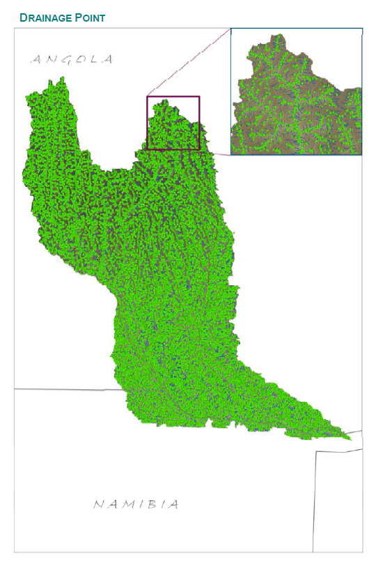
Okavango Basin Contributing Area - Hydrology Modelling - Drainage Point
This vector layer (point) represents the points at which stream segments intersect in the CORB-Contributing area, and can aid in the identified of locations for potential hydrological monitoring. This was created by an interpolation of all stream intersections in the Drainage Line layer.
This dataset is part of the GIS Database for the Environment Protection and Sustainable Management of the Okavango River Basin project (EPSMO). Detailed information on the database can be found in the “GIS Database for the EPSMO Project†document produced by Luis Veríssimo (FAO consultant) in July 2009, and here available for download.
Simple
- Date (Publication)
- 2009-07-15T16:10:00
- Presentation form
- Digital map
- Purpose
-
Drainage Point Intersections model of the CORB-Contributing area.
- Status
- Completed
267-680-0024
- Maintenance and update frequency
- As needed
- Theme
-
-
hydrology
-
drainage
-
Okavango
-
Cubango Okavango River Basin
-
CORB-contributing area
-
Okavango Active Catchment Area
-
OACA
-
Tag_AQUASTAT
-
- Place
-
-
Africa
-
Okavango river basin
-
Cubango Okavango
-
- Access constraints
- Copyright
- Use constraints
- Copyright
- Other constraints
-
Users must assume responsibility in determining the usability of this data for their purposes. User must include full citation (author, pubdate, title, and source fields in associated attribute table) for the theme polygons when using the data in printed or digital form. Credit should be given to the data source when data is transferred or printed. Source should be cited as: Environment Protection and Sustainable Management of the Okavango River Basin Project /EPSMO.
- Other constraints
-
All rights reserved. FAO encourages the reproduction and dissemination of material in this information product. Non commercial uses will be authorized free of charge, upon request. Reproduction for resale or other commercial purposes, including educational purposes, may incur fees. Applications for permission to reproduce or disseminate FAO copyright materials, and all queries concerning rights and licences, should be addressed by e-mail to copyright@fao.org or to the Chief, Publishing Policy and Support Branch, Office of Knowledge Exchange, Research and Extension, FAO, Viale delle Terme di Caracalla, 00153 Rome, Italy.
- Spatial representation type
- Vector
- Denominator
- 200000
- Metadata language
-
eng
- Character set
- UTF8
- Topic category
-
- Inland waters
- Geoscientific information
))
Vertical extent
- Supplemental Information
-
The EPSMO Project was initiated in 2001 by the Permanent Okavango River Basin Water Commission (OKACOM) with the support of the Global Environment Facility, the United Nations Development Programme (UNDP) and the Food and Agriculture Organization of the United Nations. Main outputs include the completion of a Trans-boundary Diagnostic Analysis (TDA), and a Strategic Action programme (SAP) for the Basin. As a background for the TDA and the Environmental Flows Assessment report, a GIS database was produced and it is here made available through selected thematic layers organized in themes. The GIS database has been also used as an input component of the Cubango-Okavango River Basin Water Audit carried on by FAO in partnership with OKACOM (GCP/INT/072/ITA , http://www.fao.org/nr/water/projects_scarcity_phase2.html ).
- Reference system identifier
- GCS_WGS84
- OnLine resource
- OKACOM - The Permanent Okavango River Basin Water Commission ( WWW:LINK-1.0-http--link )
- OnLine resource
- EPSMO website ( WWW:LINK-1.0-http--link )
- OnLine resource
- FAO Water â Projects â Water Scarsity, the role of agriculture ( WWW:LINK-1.0-http--link )
- OnLine resource
-
GIS_Database_EPSMO.pdf
(
WWW:DOWNLOAD-1.0-http--download
)
GIS Database for the EPSMO Project Report
- OnLine resource
-
OACA_DrainagePointIntersections.zip
(
WWW:DOWNLOAD-1.0-http--download
)
Okavango Basin Contributing Area - Drainage Point
- OnLine resource
- https://data.apps.fao.org/map/catalog/srv/eng/resources.get?id=42601&fname=&access=private ( WWW:DOWNLOAD-1.0-http--download )
- OnLine resource
- https://data.apps.fao.org/map/catalog/srv/eng/resources.get?id=42601&fname=&access=private ( WWW:DOWNLOAD-1.0-http--download )
- Hierarchy level
- Dataset
- Statement
-
Attribution of the data set was checked for data entry errors through a series of reviews that checked for inconsistencies with interpretation results. The coverage has been checked for label and topologic errors and attribution is complete.
- File identifier
- 86879791-7199-404d-ad13-b5f731e64c66 XML
- Metadata language
-
eng
- Character set
- UTF8
- Date stamp
- 2020-01-30T14:38:30
- Metadata standard name
-
ISO 19115:2003/19139
- Metadata standard version
-
1.0
Overviews
Spatial extent
Provided by
