 Stars4Water
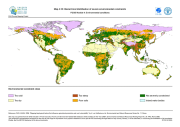
Hierarchical distribution of severe environmental constraints (FGGD)
The FGGD severe environmental constraints map is a global raster datalayer with a resolution of 5 arc-minutes. Pixels with no severe environmental constraints contain a value of zero. Each other pixel contains a cumulative class value that shows which environmental constraint is binding in the pixel area. The data are from FAO and IIASA, 2000, Global agro-ecological zones, as reported in FAO and IIASA, 2007, Mapping biophysical factors that influence agricultural production and rural vulnerability, by H. von Velthuizen et al.
Simple
- Date (Publication)
- 2007-08-23
- Edition
-
1.0
- Presentation form
- Digital map
- Purpose
-
The FGGD Digital Atlas consists of more than 100 global database that allows to analyse food insecurity and poverty in relation to the environment.
- Status
- Completed
- Maintenance and update frequency
- As needed
- Theme
-
-
Environmental constraints
-
- Place
-
-
World
-
- Access constraints
- Copyright
- Use constraints
- Copyright
- Spatial representation type
- Grid
- Metadata language
-
eng
- Character set
- UTF8
- Topic category
-
- Environment
- Biota
))
- Supplemental Information
-
This dataset is contained in Module 4 "Environmental conditions" of Food Insecurity, Poverty and Environment Global GIS Database (FGGD) (FAO, 2007).
- Reference system identifier
- GCS_WGS_1984
- Number of dimensions
- 2
- Dimension name
- Row
- Dimension size
- 2160
- Resolution
- 0.08333333 ,
- Dimension name
- Column
- Dimension size
- 4320
- Resolution
- 0.08333333 ,
- Cell geometry
- Area
- Transformation parameter availability
- Yes
- Distribution format
-
-
TIFF
(
)
-
TIFF
(
)
- OnLine resource
-
Map4_10.zip
(
WWW:DOWNLOAD-1.0-http--download
)
Hierarchical distribution of severe environmental constraints - Grid format (1.05 MB)
- OnLine resource
-
geonetwork:constr_hier_14065
(
OGC:WMS-1.1.1-http-get-map
)
Hierarchical distribution of severe environmental constraints (FGGD)
- OnLine resource
- Mapping biophysical factors that influence agricultural production and rural vulnerability ( WWW:LINK-1.0-http--link )
Data quality info
- File identifier
- 91103200-74b2-11db-b9b2-000d939bc5d8 XML
- Metadata language
-
eng
- Character set
- UTF8
- Date stamp
- 2023-02-02T14:16:26
- Metadata standard name
-
ISO 19115:2003/19139
- Metadata standard version
-
1.0
Overviews

Spatial extent
Provided by
