Agri-environmental indicator - irrigation
The indicator assesses the trend of the irrigable and irrigated areas and their share of the total utilised agricultural area (UAA). The irrigable area is the area which is equipped for irrigation. This area does not show so much variation from year to year as it is costly for the farmer to invest in irrigation equipment. The irrigated area measures the actual amount of land irrigated and can vary significantly from year to year due to, for instance, meteorological conditions or the choice of crop.
Simple
- Date (Publication)
- 2019-01-18
- Status
- Planned
- Maintenance and update frequency
- As needed
- Theme
-
-
Rhine
-
Ribasim
-
Agriculture
-
Irrigation
-
agricultural area
-
socioeconomic
-
- Place
-
-
World
-
- Access constraints
- Other restrictions
- Use constraints
- otherRestictions
- Other constraints
-
Reproduction is authorised, provided the source is acknowledged, save where otherwise stated. Where prior permission must be obtained for the reproduction or use of textual and multimedia information (sound, images, software, etc.), such permission shall cancel the above-mentioned general permission and shall clearly indicate any restrictions on use.
- Spatial representation type
- Text, table
- Denominator
- 1000000
- Metadata language
- English
- Character set
- UTF8
- Topic category
-
- Boundaries
- Environment
- Society
- Farming
- Begin date
- 2016-01-01
- End date
- 2016-12-31
))
- Supplemental Information
-
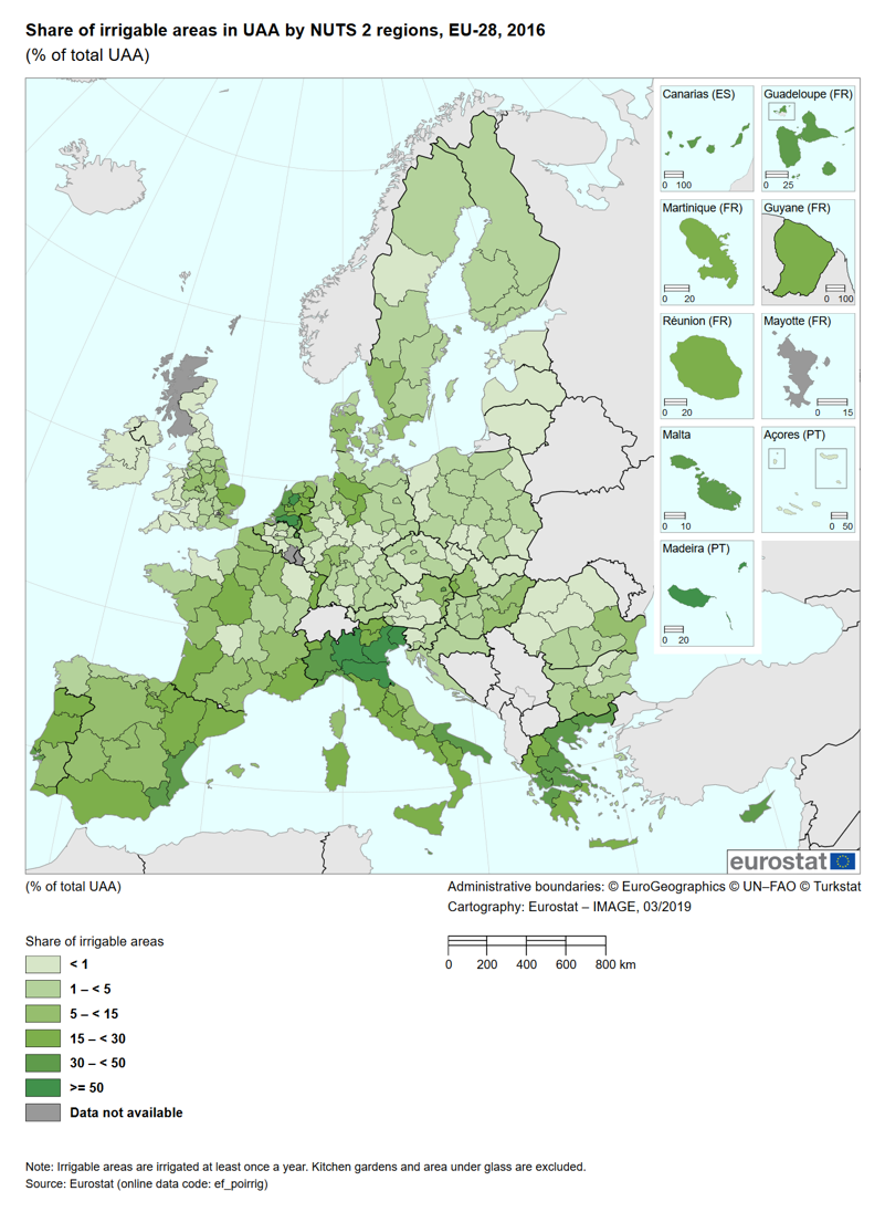
In 2016, the total agricultural area equipped for irrigation (irrigable area) in the EU[1] was 15.5 million ha (Table 1). However, the area actually irrigated (irrigated area) was lower, reaching 10.2 million hectares (ha). In fact, no country reported that all the irrigable areas had been irrigated.
The extent of irrigated area itself does not allow a statement on the actual amount of water used. Water efficiency in irrigation, as well as groundwater depletion in irrigated areas, also needs to be monitored and addressed, but is outside the scope of this fact sheet.
Irrigable and irrigated agricultural areas vary greatly among countries mainly because of regional climate and type of production. Full irrigation is needed in many types of agricultural production of southern European countries
- OnLine resource
- Agri-environmental indicator - irrigation factsheets and data ( WWW:LINK-1.0-http--link )
- OnLine resource
-
irrigated area and NUTS 2 regions 2013
(
WWW:LINK-1.0-http--link
)
Irrigation: number of farms, areas and equipment by size of irrigated area and NUTS 2 regions
- Hierarchy level
- Dataset
- File identifier
- a1be506f-72f2-48dc-a10c-82e9e5dcbda3 XML
- Metadata language
- English
- Character set
- UTF8
- Date stamp
- 2023-08-18T11:50:25
- Metadata standard name
-
ISO 19115:2003/19139
- Metadata standard version
-
1.0
Overviews
Spatial extent
Provided by
