 Stars4Water
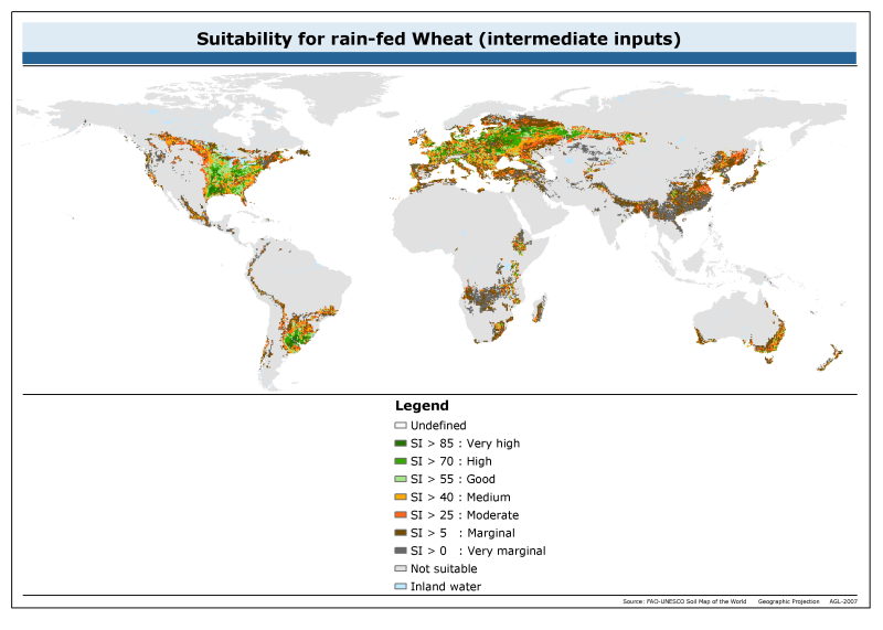
Suitability for rain-fed Wheat (intermediate inputs)
The raster dataset of suitability for rainfed wheat with intermediate inputs has a spatial resolution of 5 * 5 arc minutes and is in geographic projection. Information with regard to wheat suitability was obtained from the "Derived Soil Properties" of the FAO-UNESCO Soil Map of the World which contains raster information on soil properties.
Simple
- Date (Publication)
- 2007-02-16
- Edition
-
3.6
- Presentation form
- Digital map
- Purpose
-
This database will be used mainly for poverty and food insecurity mapping, particularly for analysing where the people live at global scales in relation to:
- Agroecological zones
- Marginal or productive lands
- Major foodcrop production systems, in particular those important to food security for the rural poor.
- Status
- Completed
- Maintenance and update frequency
- As needed
- Theme
-
-
land suitability
-
Length of Growing Period
-
LGP
-
land production
-
wheat
-
farm inputs
-
Agro Ecological Zones
-
Terrastat
-
DSMW
-
Digital Soil Map of the World
-
Tag_LUS
-
Tag_land
-
- Place
-
-
World
-
- Access constraints
- Copyright
- Spatial representation type
- Grid
- Metadata language
-
eng
- Character set
- UTF8
- Topic category
-
- Geoscientific information
))
- Supplemental Information
-
Each crop has a set of requirements as to the biophysical environment it prefers and would yield best. These requirements in terms of LGP, Thermal climate, dormancy, soil fertility, soil physical characteristics and toxic elements for wheat have been compared with actual conditions as given by the Soil Map of the World and GAEZ and a suitability rating was arrived at.
The dataset is available for download (below) in both ASCII and ESRI GRID formats. A layer (.lyr) and legend (.avl) file are provided in the downloads.
Structure of the attributes
=======================
Wheat:
--------
The classes are:
1: SI > 85: Very high
2: SI > 70: High
3: SI > 55: Good
4: SI > 40: Medium
5: SI > 25: Moderate
6: SI > 5: Marginal
7: SI > 0: Very marginal
8: Not Suitable
9: Inland Water
0: Undefined
- Reference system identifier
- WGS 1984 - Geographic
- Number of dimensions
- 3
- Dimension name
- Row
- Dimension size
- 2160
- Dimension name
- Column
- Dimension size
- 4320
- Dimension name
- Vertical
- Cell geometry
- Area
- Transformation parameter availability
- No
- OnLine resource
- FAO Land Resources - Digital Media Series (20) ( WWW:LINK-1.0-http--link )
- OnLine resource
-
wheat.zip
(
WWW:DOWNLOAD-1.0-http--download
)
Suitability for rain-fed Wheat (intermediate inputs) - ESRI GRID dataset
- OnLine resource
-
wheat_ASCII.zip
(
WWW:DOWNLOAD-1.0-http--download
)
Suitability for rain-fed Wheat (intermediate inputs) - ASCII GRID dataset
- Hierarchy level
- Dataset
- File identifier
- a7ef6230-bdc2-11db-a0f6-000d939bc5d8 XML
- Metadata language
-
eng
- Character set
- UTF8
- Date stamp
- 2019-11-22T10:29:14
- Metadata standard name
-
ISO 19115:2003/19139
- Metadata standard version
-
1.0
Overviews
Spatial extent
Provided by
