 Stars4Water
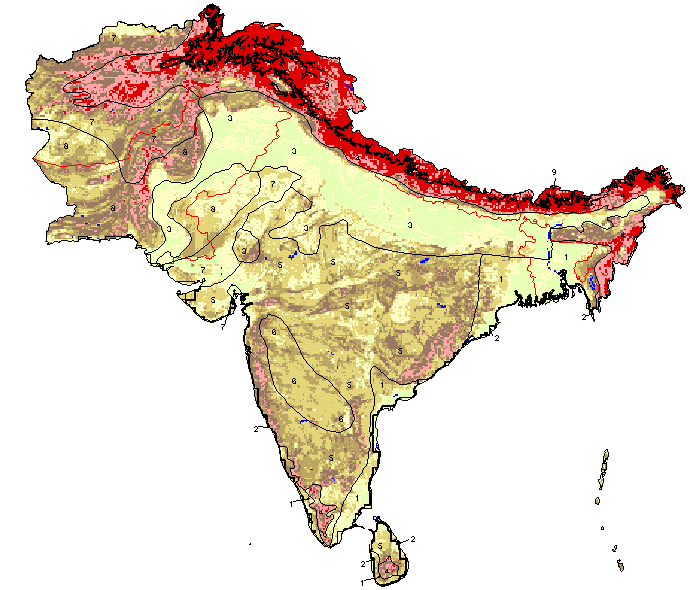
Slope of South Asia.
As part of the the World Bank's review of its rural development strategy, the Bank sought the assistance of the Food and Agriculture Organization of the United Nations (FAO) in evaluating how farming systems might change and adapt over the next thirty years. Amongst other objectives, the World Bank asked FAO to provide guidance on priorities for investment in food security, poverty reduction, and economic growth, and in particular to identify promising approaches and technologies that will contribute to these goals. The results of the study are summarized in a set of seven documents, comprising six regional reports and the global overview contained in this volume. This document, which synthesises the results of the six regional analyses as well as discussing global trends, cross-cutting issues and possible implementation modalities, presents an overview of the complete study. This document is supplemented by two case study reports of development issues of importance to farming systems globally.
Simple
- Date (Creation)
- 2001-05-01
- Edition
-
First edition.
- Presentation form
- Digital map
- Presentation form
- Digital image
- Purpose
-
The farming systems presented in this study are considered to provide an effective broad framework for the prioritisation of development actions and investments for accelerating agricultural development, particularly in ways which can reduce rural poverty and hunger.
- Status
- Completed
- Keywords
-
-
Slope
-
South Asia
-
Global Farming Systems Study
-
- Place
-
-
South Asia
-
- Spatial representation type
- Grid
- Metadata language
-
eng
- Character set
- UTF8
- Topic category
-
- Elevation
- Begin date
- 2001-05-01
))
- Supplemental Information
-
Derived from the Global Agro-Ecological Zones Study, Food and Agriculture Organization of the United Nations (FAO), Land and Water Development Division (AGL) with the collaboration of the International Institute for Applied Systems Analysis (IIASA), 2000. Two sources of geo-referenced terrain slopes were available for use in the Global AEZ assessment: (i) terrain slopes indicated in the mapping unit expansion tables of the respective soil maps, and (ii) terrain slopes derived from GTOPO30 data (EROS Data Center, 1998). The latter terrain-slope database was established at IIASA using a rule-based algorithm to calculate slope distributions in terms of seven slope classes per 5 minute grid-cell of the DSMW soil data based on neighborhood relationships among grid-cells in the 30 arc-second GTOPO30 database. Slopes derived from the 30 arc-second DEM were allocated to soil units occurring within individual soil associations. This involved five steps: (i) Determination of slope classes for each 30 arc-second grid-cell of GTOPO30. Results are grouped in the following seven classes: 0-2%, 2-5%, 5-8%, 8-16%, 16-30%, 30-45% and > 45%; (ii) Aggregation of the results respectively to 5 minute latitude/longitude DSMW grid-cells, and to individual soil association map units resulting in a slope class distribution for each grid-cell and map unit; (iii) Defining ?priority? classes of soil unit/slope relationships; (iv) Establishing for each soil association consistent rankings of slopes/soil units; (v) Allocation of individual soil units within a particular soil association map unit to 5 min grid-cells of the DSMW, according to calculated slope distributions.
- OnLine resource
- Link to The World Bank Group - Agriculture and Rural Development ( WWW:LINK-1.0-http--link )
- OnLine resource
-
1078.zip
(
WWW:DOWNLOAD-1.0-http--download
)
Slope of South Asia- gridfile
- Hierarchy level
- Dataset
- Description
-
Last Updated
- Date / Time
- 2002-05-31 19:58:00
- File identifier
- c86a15f0-88fd-11da-a88f-000d939bc5d8 XML
- Metadata language
-
eng
- Character set
- UTF8
- Date stamp
- 2010-01-06T18:34:27
- Metadata standard name
-
ISO 19115:2003/19139
- Metadata standard version
-
1.0
Overviews

Spatial extent
Provided by
