 Stars4Water
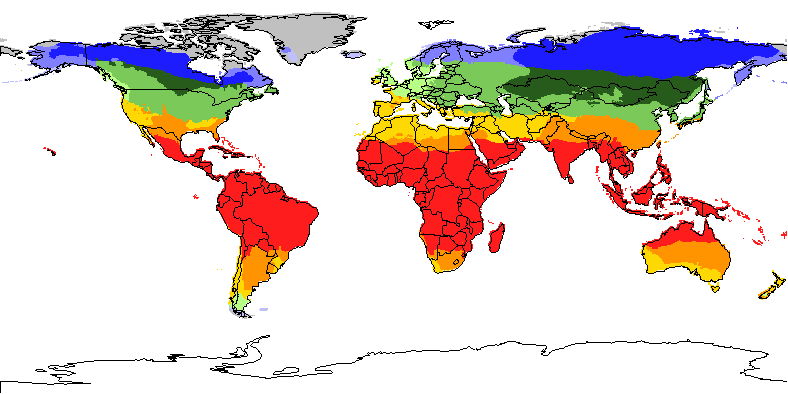
Global thermal climates
The thermal climates represent major latitudinal climatic zones. They were obtained through classifying monthly temperatures corrected to sea level (with an assumed lapse rate: 0.55°C/100m). The latitudinal thermal climates distinguished in global AEZ are the following: tropics, subtropics with summer rainfall, subtropics with winter rainfall, temperate, boreal and polar/arctic. The temperate and boreal belts have been further subdivided according to continentality into three classes, namely: oceanic, sub-continental and continental.
Data derived from analysis over 37 years.
Simple
- Date (Creation)
- 2000-05-01
- Edition
-
First edition.
- Presentation form
- Digital map
- Purpose
-
The AEZ methodology for land productivity assessments follows an environmental approach; it provides a framework for establishing a spatial inventory and database of land resources and crop production potentials. This land resources inventory is used to assess, for specified management conditions and levels of inputs, the suitability of crops/LUTs in relation to both rain-fed and irrigated conditions, and to quantify expected production of cropping activities relevant in the specific agro-ecological context.
- Status
- On going
- Keywords
-
-
temperature
-
Tag_LUS
-
Tag_land
-
- Keywords
-
-
climate
-
- Keywords
-
-
Agroecological zones
-
Agro-ecological Zoning Database
-
AEZ
-
- Place
-
-
World
-
- Spatial representation type
- Grid
- Metadata language
-
eng
- Character set
- UTF8
- Topic category
-
- Climatology, meteorology, atmosphere
- Begin date
- 2000-05-01
))
- Supplemental Information
-
The Food and Agriculture Organization of the United Nations (FAO) with the collaboration of the International Institute for Applied Systems Analysis (IIASA), has developed a system that enables rational land-use planning on the basis of an inventory of land resources and evaluation of biophysical limitations and potentials. This is referred to as the Agro-ecological Zones (AEZ) methodology.
- OnLine resource
- Global Agro-Ecological Zones (Global AEZ) CD-ROM FAO/IIASA, 2000 ( WWW:LINK-1.0-http--link )
- OnLine resource
- FAO Land Resources - Digital Media Series ( WWW:LINK-1.0-http--link )
- OnLine resource
-
68.zip
(
WWW:DOWNLOAD-1.0-http--download
)
Global thermal climates - bil format and image
- OnLine resource
-
geonetwork:plate03_68
(
OGC:WMS-1.1.1-http-get-map
)
Global thermal climates
- Hierarchy level
- Dataset
- Description
-
Last Updated
- Date / Time
- 2002-05-31 19:58:00
- File identifier
- ca091ff0-88fd-11da-a88f-000d939bc5d8 XML
- Metadata language
-
eng
- Character set
- UTF8
- Date stamp
- 2019-11-22T10:23:15
- Metadata standard name
-
ISO 19115:2003/19139
- Metadata standard version
-
1.0
Overviews

Spatial extent
Provided by
