Water sector indicators of hydrological change across Europe from 2011 to 2095 derived from climate simulations
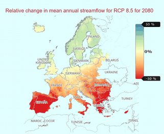
The dataset provides a number of indicators of the potential change, relative to a reference period of the recent past, in hydrological conditions over the 21st Century based on an ensemble of climate and hydrological models. The indicators cover hydrological variables of river discharge, soil moisture, snow water equivalent and groundwater recharge. These indicators are produced by various hydrological models using input variables of historical and projected precipitation, temperature and potential evapotranspiration.
The indicators transform data from climate projections into usable information for the European water sector. They were defined in discussion with stakeholder groups working in different areas of the water sector (hydropower, irrigation, water supply) to provide clear information on climate projections for water resources as annual, seasonal and monthly change factors for a range of variables.
A range of global climate models and standard projection scenarios (based on latest Copernicus Climate Change Service and Coupled Model Inter-comparison Project Phase 5 climate modelling experiments) were used along a multi-hydrological model approach to produce these indicators.
This ensemble approach to the climate and hydrological modelling captures the uncertainty and variability of the hydrological regime. Precipitation and temperature data from five global climate models was downscaled to 5km x 5km resolution with the daily values disaggregated to 3-hourly values. These data were used to force four hydrological models to produce the hydrological variables to derive the indicators. The indicators are given as relative changes for a given 30-year projection window with respect to the reference period estimates of 1971-2010 for Representative Concentration Pathways (RCP) 2.6 and 8.5, for each grid cell.
This dataset is produced on behalf of Copernicus Climate Change Service, by UK Centre for Ecology & Hydrology (UKCEH), Helmholtz Centre for Environmental Research (UFZ), Leipzig, Centro Tecnológico del Agua (Cetaqua), Climate Partnership LLC (CPL), Environment Agency (EA), Mediterranean Network of Basin Organisations (MENBO), Norwegian Water Resources & Energy Directorate (NVE).
Simple
- Date (Revision)
- 2025-03-11
- Status
- Historical archive
- Maintenance and update frequency
- Not planned
- Theme
-
-
hydrological condition
-
Sectoral Climate Impact Indicators
-
ensemble of climate and hydrological models
-
Terrestial Essential Climate Variables
-
river discharge
-
soil moisture
-
settled snow
-
groundwater recharge
-
water availability
-
- Place
-
-
World
-
- Access constraints
- Copyright
- Use constraints
- otherRestictions
- Other constraints
-
See https://cds.climate.copernicus.eu/api/v2/terms/static/licence-to-use-copernicus-products.pdf
- Spatial representation type
- Grid
- Denominator
- 200000
- Metadata language
-
eng
- Character set
- UTF8
- Topic category
-
- Boundaries
- Begin date
- 2011-01-01
- End date
- 2095-01-01
))
- Reference system identifier
- WGS 1984
- Number of dimensions
- 3
- Dimension name
- Row
- Resolution
- 5 km
- Dimension name
- Column
- Resolution
- 5 km
- Cell geometry
- Area
- Distribution format
-
-
NetCDF-4
(
)
-
NetCDF-4
(
)
- Hierarchy level
- Dataset
- File identifier
- e078bb36-d8db-47a6-89f5-03a78ddff35d XML
- Metadata language
- English
- Character set
- UTF8
- Date stamp
- 2025-03-11T17:04:39
- Metadata standard name
-
ISO 19115:2003/19139
- Metadata standard version
-
1.0
Overviews
Spatial extent
Provided by
