 Stars4Water
Princeton Meteorological Forcing Dataset for Africa - ClimAfrica WP1
Bias-corrected and downscaled future climate meterological forcing data for Africa, for the period 1948-2099. This dataset is derived from the Global Meteorological Forcing Dataset for Land Surface Modeling, produced by the Princeton University [Department of Civil and Environmental Engineering]. The source data is a 150-yr (1948-2099) dataset of meteorological forcings for driving land surface models and other land modeling schemes. It is derived by bias correcting and downscaling WCRP CMIP3 climate model data for the 20th century and 21st century future climate projections. The dataset is bias-corrected and downscaled using the newly developed equidistant quantile matching method (Li et al., 2010) which better represents changes in the full distribution (not just the mean change). In addition to precipitation and temperature, radiation, humidity, pressure and windspeed are also downscaled. The downsclaing is based on the observational based global forcing dataset of Sheffield et al. (2006) also available from this website. The dataset is currently available at 1.0 degree, 3-hourly resolution globally for 1948-2008. Experimental versions include a 1901-2008 version, real-time updates, higher resolution versions at 0.25deg and 0.5deg and future climate projections based on bias-corrected climate model output.
The data are currently available for one climate model (NCAR-PCM1) for the 20th century historical forcing (20C3M; 1948-2000) and one future climate scenario (SRES A2; 2001-2099).
This work was supported by NSF Project 0629471 "Collaborative research: Understanding change in the climate and hydrology of the Arctic land region: Synthesizing the results of the ARCSS Fresh Water Initiative Projects".
Variables description
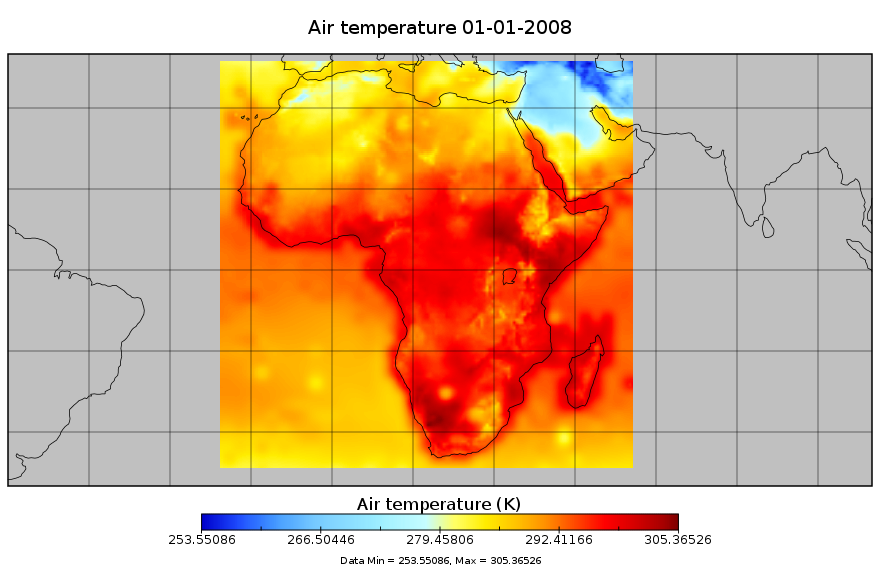
Tair: 2 m air temperature (K)
PSurf: 2 m surface pressure (Pa)
Qair: specific humidity (kg/kg)
Wind: 10m wind speed (m/s)
Precip: precipitation (mm)
LWdown: Downwards long-wave radiation flux (W/m-2)
LWnet: Net short-wave radiation flux (W/m-2)
SWdown: Downwards short-wave radiation flux (average) (W/m-2)
This data set has been produced for driving land surface models and other land modeling schemes, in the framework of the "Climate change predictions in Sub-Saharan Africa: impacts and adaptations (ClimAfrica)" project, Work Package 1 (WP1).
Simple
- Date (Publication)
- 2014-05-15T11:20:00
- Edition
-
First
- Presentation form
- Digital map
- Purpose
-
This data set has been produced in the framework of the "Climate change predictions in Sub-Saharan Africa: impacts and adaptations (ClimAfrica)" project, Work Package 1 (WP1).
WP1 (Past climate variability) aimed to provide consolidated data to other WPs in ClimAfrica, and to analyze the interactions between climate variability, water availability and ecosystem productivity of Sub-Saharan Africa. Various data streams that diagnose the variability of the climate, in particular the water cycle, and the productivity of ecosystems in the past decades, have been collected, analyzed and synthesized. The data streams range from ground-based observations and satellite remote sensing to model simulations. More information on ClimAfrica project is provided in the Supplemental Information section of this metadata.
- Status
- Completed
- Maintenance and update frequency
- Daily
- Theme
-
-
meteorology
-
climate
-
Lwdown
-
Lwnet
-
Psurf
-
Swdown
-
Precip
-
Qair
-
Qmean
-
Tair
-
Tmax
-
Tmin
-
Wind
-
temperature
-
air temperature
-
pressure
-
humidity
-
radiation
-
WP1
-
ClimAfrica
-
Tag_climafrica
-
- Place
-
-
Africa
-
- Access constraints
- Copyright
- Use constraints
- Copyright
- Other constraints
-
The dataset is freely available but, please, cite the references below if you use the data. Li, H., J. Shefffield, and E. F. Wood, 2010: Bias correction of monthly precipitation and temperature fields from Intergovernmental Panel on Climate Change AR4 models using equidistant quantile matching, J. Geophys. Res., 115, D10101, DOI:10.1029/2009JD012882. Sheffield, J., G. Goteti, and E. F. Wood, 2006: Development of a 50-yr high-resolution global dataset of meteorological forcings for land surface modeling, J. Climate, 19 (13), 3088-3111
- Spatial representation type
- Grid
- Distance
- 0.5 Degree
- Metadata language
- English
- Character set
- UTF8
- Topic category
-
- Climatology, meteorology, atmosphere
- Begin date
- 1901-01-01
- End date
- 2008-12-31
))
- Supplemental Information
-
ClimAfrica was an international project funded by European Commission under the 7th Framework Programme (FP7) for the period 2010-2014. The ClimAfrica consortium was formed by 18 institutions, 9 from Europe, 8 from Africa, and the Food and Agriculture Organization of United Nations (FAO).
ClimAfrica was conceived to respond to the urgent international need for the most appropriate and up-to-date tools and methodologies to better understand and predict climate change, assess its impact on African ecosystems and population, and develop the correct adaptation strategies. Africa is probably the most vulnerable continent to climate change and climate variability and shows diverse range of agro-ecological and geographical features. Thus the impacts of climate change can be very high and can greatly differ across the continent, and even within countries.
The project focused on the following specific objectives:
1. Develop improved climate predictions on seasonal to decadal climatic scales, especially relevant to SSA;
2. Assess climate impacts in key sectors of SSA livelihood and economy, especially water resources and agriculture;
3. Evaluate the vulnerability of ecosystems and civil population to inter-annual variations and longer trends (10 years) in climate;
4. Suggest and analyse new suited adaptation strategies, focused on local needs;
5 Develop a new concept of 10 years monitoring and forecasting warning system, useful for food security, risk management and civil protection in SSA;
6. Analyse the economic impacts of climate change on agriculture and water resources in SSA and the cost-effectiveness of potential adaptation measures.
The work of ClimAfrica project was broken down into the following work packages (WPs) closely connected. All the activities described in WP1, WP2, WP3, WP4, WP5 consider the domain of the entire South Sahara Africa region. Only WP6 has a country specific (watershed) spatial scale where models validation and detailed processes analysis are carried out.
- Reference system identifier
- WGS 1984
- Distribution format
-
-
GeoTIFF
(
1.0
)
-
GeoTIFF
(
1.0
)
- OnLine resource
-
Bias-Corrected and Downscaled Future Climate Global Meterological Forcing Data: 1948-2099
(
WWW:DOWNLOAD-1.0-http--download
)
Princeton University - Terrestrial Hydrology Research Group
- OnLine resource
- Climafrica Website - Climate Change Predictions In Sub-Saharan Africa: Impacts And Adaptations ( WWW:LINK-1.0-http--link )
- OnLine resource
- Scenarios of major production systems in Africa ( WWW:LINK-1.0-http--link )
- File identifier
- e1aaf842-6c35-4e4f-ab8f-295662fcb8da XML
- Metadata language
- English
- Character set
- UTF8
- Date stamp
- 2023-01-24T09:15:41
- Metadata standard name
-
ISO 19115:2003/19139
- Metadata standard version
-
1.0
Overviews
Spatial extent
Provided by
