 Stars4Water
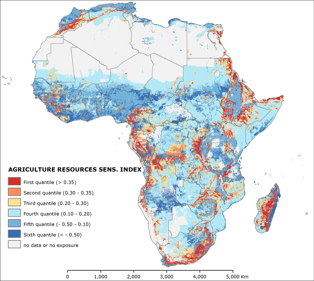
Agriculture resources sensitivity index (2010) - ClimAfrica WP4
The “agriculture resources sensitivity” represents the agriculture potential in 2010. This potential is measured by the availability of land and food production per capita, and the main thread to agriculture land, represented by desertification risk. The index results from the second cluster of the Principal Component Analysis preformed among 16 potential variables. The analysis identify four dominant variables, namely “potential rain-fed food production per capita”, “cropland crowding”, “desertification index” and “topographic resources availability”, assigning respectively the weights of 0.29, 0.29, 0.27 and 0.15. Before to perform the analysis all the variables were log transformed to shorten the extreme variation and then were score-standardized (converted to distribution with average of 0 and standard deviation of 1; all variables with inverse method except “desertification index”) in order to be comparable. The 5 arc-minute grid “potential rain-fed food production per capita” of 2007 was gathered from FAO GeoNetwork and then sampled at 0.5 arc-minutes. It was multiplied by crop land occurrence dataset, extracted from the FAO Global Land Cover-SHARE dataset of 2014 and divided by population grid in order to compute the per capita values. The 0.5 arc-minute grid “cropland crowding” of 2010 was produced dividing the crop land occurrence (FAO Global Land Cover-SHARE) by the population. The 0.5 arc-minute grid “desertification index” of 2000 was measured in terms of number of months recording values less than 0.75 of the ratio between precipitation (current monthly average) and potential evapo-transpiration (PET, current monthly average). Data of precipitation and PET were gathered from Worldclim and from CGIAR Consortium for Spatial Information, respectively. Finally the 0.5 arc-minute grid “topographic resources availability” was produced within the ClimAfrica project based on SRTM DEM of NASA. The “potential rain-fed food production per capita” measures the availability of food in a certain area produced with subsistence techniques. Cells with low food production are sensitive to climate change impacts because the low input agriculture (dominant in Africa) may not produced sufficient food quantities to support the local populations. The “cropland crowding” is an indicator that assess the availability of crop land hectares per 1,000 people. Sensitive areas are where few crop lands are shared by large population. The “desertification index” assesses the climatological risk of a certain area to be subjected to desertification due to lack of rainfall. Such areas are more sensitive to lost crop land and thus food production quantities due to climate change impacts. The “topographic resources availability” is the percentage of each cell with slopes equal to or lower than 15 %. Landscapes strongly dissected contain less land with agriculture values than plain landscapes. The scarcity of agriculture land may increase the fragility of a system because unable to increase to crop surface to cope with climate change impacts.
This dataset has been produced in the framework of the “Climate change predictions in Sub-Saharan Africa: impacts and adaptations (ClimAfrica)” project, Work Package 4 (WP4). More information on ClimAfrica project is provided in the Supplemental Information section of this metadata.
Simple
- Date (Creation)
- 2014-09-01T00:00:00
- Presentation form
- Digital map
- Purpose
-
Purpose of WP4 - D4.3 is to establish a medium-term warning system (based on ClimAfrica data) that produces prospective analyses about climate change impacts on agriculture for the next 10 years. This will fill the gap between seasonal scale predictions and long-term impact scenarios, and identify the future Areas of Concerns (AoCs) and likely hotspots of vulnerabilities.
- Status
- Completed
- Maintenance and update frequency
- As needed
- Theme
-
-
topographic resources
-
desertification
-
cropland crowding
-
potential rainfed production
-
sensitivity
-
WP4
-
ClimAfrica
-
Tag_climafrica
-
- Place
-
-
Africa
-
- Access constraints
- Copyright
- Spatial representation type
- Grid
- Distance
- 30 arc/sec
- Metadata language
- English
- Character set
- UTF8
- Topic category
-
- Society
))
- Supplemental Information
-
ClimAfrica was an international project funded by European Commission under the 7th Framework Programme (FP7) for the period 2010-2014. The ClimAfrica consortium was formed by 18 institutions, 9 from Europe, 8 from Africa, and the Food and Agriculture Organization of United Nations (FAO).
ClimAfrica was conceived to respond to the urgent international need for the most appropriate and up-to-date tools and methodologies to better understand and predict climate change, assess its impact on African ecosystems and population, and develop the correct adaptation strategies. Africa is probably the most vulnerable continent to climate change and climate variability and shows diverse range of agro-ecological and geographical features. Thus the impacts of climate change can be very high and can greatly differ across the continent, and even within countries.
The project focused on the following specific objectives:
1. Develop improved climate predictions on seasonal to decadal climatic scales, especially relevant to SSA;
2. Assess climate impacts in key sectors of SSA livelihood and economy, especially water resources and agriculture;
3. Evaluate the vulnerability of ecosystems and civil population to inter-annual variations and longer trends (10 years) in climate;
4. Suggest and analyse new suited adaptation strategies, focused on local needs;
5 Develop a new concept of 10 years monitoring and forecasting warning system, useful for food security, risk management and civil protection in SSA;
6. Analyse the economic impacts of climate change on agriculture and water resources in SSA and the cost-effectiveness of potential adaptation measures.
The work of ClimAfrica project was broken down into the following work packages (WPs) closely connected. All the activities described in WP1, WP2, WP3, WP4, WP5 consider the domain of the entire South Sahara Africa region. Only WP6 has a country specific (watershed) spatial scale where models validation and detailed processes analysis are carried out.
- Reference system identifier
- GCS WGS 84 (EPSG Ellipsoid 7030)
- Distribution format
-
-
(
GeoTff
)
-
(
GeoTff
)
- OnLine resource
-
ClimAfr17_agriculture_resources_sens_index.zip
(
WWW:DOWNLOAD-1.0-http--download
)
Agriculture resources sensitivity index (2010)
- OnLine resource
-
geonetwork:climafr17_agri_resources_sens_index_48379
(
OGC:WMS-1.1.1-http-get-map
)
Agriculture resources sensitivity index (2010)
- OnLine resource
-
Scenarios of major production systems in Africa
(
WWW:LINK-1.0-http--link
)
Project deliverable D4.1 - Scenarios of major production systems in Africa
- OnLine resource
-
CLIMAFRICA – Climate change predictions in Sub-Saharan Africa: impacts and adaptations
(
WWW:LINK-1.0-http--link
)
Climafrica Website - Climate Change Predictions In Sub-Saharan Africa: Impacts And Adaptations
- File identifier
- e74668b3-6ee8-4167-89cf-b15f8ebf515e XML
- Metadata language
- English
- Character set
- UTF8
- Date stamp
- 2023-01-24T08:49:17
- Metadata standard name
-
ISO 19115:2003/19139
- Metadata standard version
-
1.0
Overviews

Spatial extent
Provided by
