 Stars4Water
Global Bovine Density (2005)
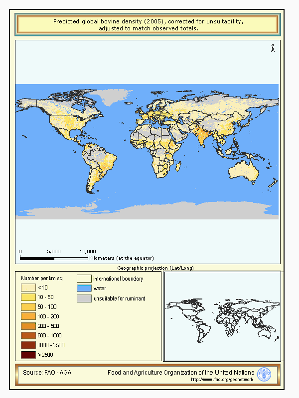
This dataset forms part of a global livestock mapping project by the Food and Agriculture Organization's Animal Production and Health Division (FAO-AGA). The methodology and sources of data are fully described in a document entitled: "The Gridded Livestock of the World FAO (2006)". In summary, for each country the most recent available sub-national livestock census data and corresponding administrative boundaries have been collected. These are then converted into densities, excluding land unsuitable for livestock (either monogastric or ruminant), to provide the 'observed' data. The data are then disaggregated based on statistical relations with some environmental variables in similar agro-ecological zones to produce the 'predicted' distribution. The predicted data are further manipulated to match national census totals for the year 2000 according to the FAOSTAT database. The project includes: a global network of data providers on livestock and sub-national boundaries; an Oracle database in which these data are managed and processed; a system for predicting livestock distributions based on environmental data and an interactive web application, the Global Livestock Production and Health Atlas (GLiPHA - http://www.fao.org/ag/aga/glipha/index.jsp ), through which data are viewed and disseminated. The files are in a raster GRID format, with an ArcGis layer file and an ArcView legend file. Pixel values represent actual densities (per square kilometre). Projection details are given in the metadata. The map should ideally be viewed with the overlay of national boundaries, water bodies and unsuitable land. All of these supplementary data are available in three accompanying zip files. These data have been produced by FAO's Animal Production and Health Division in collaboration with ERGO and the TALA research group, University of Oxford, UK.
Simple
- Date (Creation)
- 2005
- Edition
-
1.0
- Edition date
- 2005
- Presentation form
- Digital map
+ 39 06 570 55749
- Keywords
-
-
bovine
-
large ruminant
-
livestock
-
GLW
-
FAO
-
Tag_AGAL
-
- Place
-
-
World
-
- Spatial representation type
- Grid
- Metadata language
-
eng
- Topic category
-
- Farming
- Biota
- Environment
- Boundaries
- Imagery base maps earth cover
- Environment description
-
Microsoft Windows 2000 Version 5.0 (Build 2195) Service Pack 4; ESRI ArcCatalog 8.3.0.800
))
- Reference system identifier
- GCS_WGS_1984
- Number of dimensions
- 2
- Dimension name
- Row
- Dimension size
- 1180
- Dimension name
- Column
- Dimension size
- 1460
- Cell geometry
- Area
- Transformation parameter availability
- Distribution format
-
-
ZIP
(
)
-
ZIP
(
)
- OnLine resource
-
glbbvobs.zip
(
WWW:DOWNLOAD-1.0-http--download
)
Observed global bovine density (2005), corrected for unsuitability - (1.3 Mb)
- OnLine resource
-
glbbv2kcor.zip
(
WWW:DOWNLOAD-1.0-http--download
)
Predicted global bovine density (2005), corrected for unsuitability, adjusted to match FAOSTAT totals for the year 2000 (the FAOSTAT 2000) - (12 Mb)
- OnLine resource
-
water_admin_mask.zip
(
WWW:DOWNLOAD-1.0-http--download
)
Supplementary data pt. 1 (overlays, area files, etc.) - (19.7 Mb)
- OnLine resource
-
unsuitability.zip
(
WWW:DOWNLOAD-1.0-http--download
)
Supplementary data pt. 2 (overlays, area files, etc.) - (20.2 Mb)
- OnLine resource
-
projects.zip
(
WWW:DOWNLOAD-1.0-http--download
)
Supplementary data pt. 3 (overlays, area files, etc.) - (0.3 Mb)
- OnLine resource
-
glbbv_fig.zip
(
WWW:DOWNLOAD-1.0-http--download
)
Graphics only - (0.1 Mb)
- OnLine resource
-
glbbvtotcor.zip
(
WWW:DOWNLOAD-1.0-http--download
)
Predicted global bovine density (2005), corrected for unsuitability, adjusted to match observed totals - (12) Mb)
OnLine resource
- OnLine resource
-
geonetwork:glbbvd1f0503m_12715
(
OGC:WMS-1.1.1-http-get-map
)
Global Bovine Density (2005)
- Hierarchy level
- Dataset
- Statement
-
The acompanying document for this dataset (see Abstract) provides details of the methology used and of the sources of livestock data that contributed to it. The lineage for individual countries are not provided in the global metadata file, but can be found in the metadata for each region.
- File identifier
- f8e9b460-88fd-11da-a88f-000d939bc5d8 XML
- Metadata language
-
eng
- Character set
- UTF8
- Hierarchy level
- Dataset
- Hierarchy level name
-
dataset
- Date stamp
- 2025-07-14T10:10:05
- Metadata standard name
-
ISO 19115:2003/19139
- Metadata standard version
-
1.0
Overviews
Spatial extent
Provided by
