 Stars4Water
zip
Type of resources
Available actions
Topics
Keywords
Contact for the resource
Provided by
Formats
Representation types
status
Scale
Resolution
-
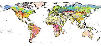
Soil information, from the global to the local scale, has often been the one missing biophysical information layer, the absence of which has added to the uncertainties of predicting potentials and constraints for food and fiber production. The lack of reliable and harmonized soil data has considerably hampered land degradation assessments, environmental impact studies and adapted sustainable land management interventions. Recognizing the urgent need for improved soil information worldwide, particularly in the context of the Climate Change Convention and the Kyoto Protocol for soil carbon measurements and the immediate requirement for the FAO/IIASA Global Agro-ecological Assessment study (GAEZ v3.0), the Food and Agriculture Organization of the United Nations (FAO) and the International Institute for Applied Systems Analysis (IIASA) took the initiativeof combining the recently collected vast volumes of regional and national updates of soil information with the information already contained within the 1:5,000,000 scale FAOUNESCO Digital Soil Map of the World, into a new comprehensive Harmonized World Soil Database (HWSD). This database was achieved in partnership with: • ISRIC-World Soil Information together with FAO, which were responsible for the development of regional soil and terrain databases and the WISE soil profile database; • the European Soil Bureau Network, which had recently completed a major update of soil information for Europe and northern Eurasia, and • the Institute of Soil Science, Chinese Academy of Sciences which provided the recent 1:1,000,000 scale Soil Map of China.
-
Version 3.1 of the ISRIC-WISE database (WISE3) was compiled from a wide range of soil profile data collected by many soil professionals worldwide. All profiles have been harmonized with respect to the original Legend (1974) and Revised Legend (1988) of FAO-Unesco. Thereby, the primary soil data ─ and any secondary data derived from them ─ can be linked using GIS to the spatial units of the digitized Soil Map of the World as well as more recent digital Soil and Terrain (SOTER) databases through the soil legend code. WISE3 holds selected attribute data for some 10,250 soil profiles, with some 47,800 horizons, from 149 countries. Individual profiles have been sampled, described, and analyzed according to methods and standards in use in the originating countries. There is no uniform set of properties for which all profiles have analytical data, generally because only selected measurements were planned during the original surveys. Methods used for laboratory determinations of specific soil properties vary between laboratories and over time; sometimes, results for the same property cannot be compared directly. WISE3 will inevitably include gaps, being a compilation of legacy soil data derived from traditional soil survey, which can be of a taxonomic, geographic, and soil analytical nature. As a result, the amount of data available for modelling is sometimes much less than expected. Adroit use of the data, however, will permit a wide range of agricultural and environmental applications at a global and continental scale (1:500 000 and broader). Preferred citation: Batjes NH 2009. Harmonized soil profile data for applications at global and continental scales: updates to the WISE database. Soil Use and Management 5:124–127, http://dx.doi.org/10.1111/j.1475-2743.2009.00202.x