 Stars4Water
pH
Type of resources
Available actions
Topics
Keywords
Contact for the resource
Provided by
Formats
Representation types
status
Scale
Resolution
-
Soil pH x 10 in H2O at 6 standard depths (to convert to pH values divide by 10). Predictions were derived using a digital soil mapping approach based on Quantile Random Forest, drawing on a global compilation of soil profile data and environmental layers. This map is the result of resampling the mean SoilGrids 250 m predictions (Poggio et al. 2021) for each 5000 m cell.
-
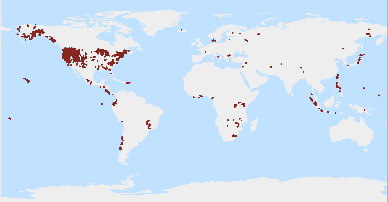
A measure of the acidity or alkalinity in soils, defined as the negative logarithm (base 10) of the activity of hydronium ions (H+) in a NaF solution, as specified in the analytical method descriptions. WoSIS_latest is a 'dynamic dataset' that contains the most recent complement of quality-assessed and standardised soil data served from WoSIS (ISRIC World Soil Information Service). The source data were shared by a wide range of data providers (see: https://www.isric.org/explore/wosis/wosis-contributing-institutions-and-experts). Being dynamic, the contents of 'wosis_latest' will change once new point data are acquired, cleansed and standardised, additional soil properties are considered, and/or when possible amendments are required. Static snapshots of 'wosis_latest' are released at irregular intervals for consistent citation purposes and to discuss methodological changes; the last snapshot is available at https://doi.org/10.5194/essd-16-4735-2024. For general information about WoSIS please see the FAQ-page at https://www.isric.org/explore/wosis/faq-wosis.
-
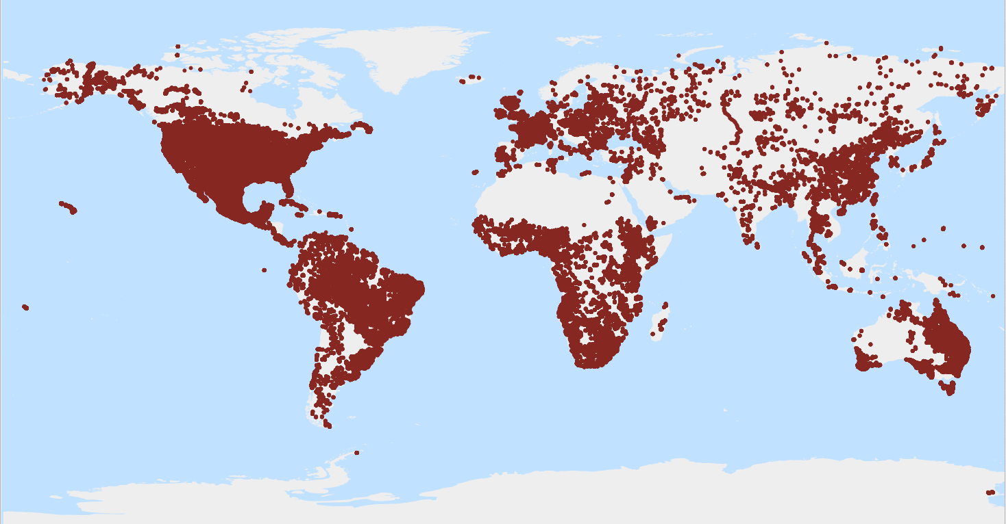
A measure of the acidity or alkalinity in soils, defined as the negative logarithm (base 10) of the activity of hydronium ions (H+) in water. WoSIS_latest is a 'dynamic dataset' that contains the most recent complement of quality-assessed and standardised soil data served from WoSIS (ISRIC World Soil Information Service). The source data were shared by a wide range of data providers (see: https://www.isric.org/explore/wosis/wosis-contributing-institutions-and-experts). Being dynamic, the contents of 'wosis_latest' will change once new point data are acquired, cleansed and standardised, additional soil properties are considered, and/or when possible amendments are required. Static snapshots of 'wosis_latest' are released at irregular intervals for consistent citation purposes and to discuss methodological changes; the last snapshot is available at https://doi.org/10.5194/essd-16-4735-2024. For general information about WoSIS please see the FAQ-page at https://www.isric.org/explore/wosis/faq-wosis.
-
Soil pH x 10 in H2O at 6 standard depths (to convert to pH values divide by 10). Predictions were derived using a digital soil mapping approach based on Quantile Random Forest, drawing on a global compilation of soil profile data and environmental layers. This map is the result of resampling the mean SoilGrids 250 m predictions (Poggio et al. 2021) for each 1000 m cell.
-
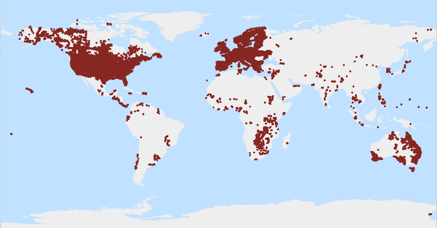
A measure of the acidity or alkalinity in soils, defined as the negative logarithm (base 10) of the activity of hydronium ions (H+) in a CaCl2 solution, as specified in the analytical method descriptions. WoSIS_latest is a 'dynamic dataset' that contains the most recent complement of quality-assessed and standardised soil data served from WoSIS (ISRIC World Soil Information Service). The source data were shared by a wide range of data providers (see: https://www.isric.org/explore/wosis/wosis-contributing-institutions-and-experts). Being dynamic, the contents of 'wosis_latest' will change once new point data are acquired, cleansed and standardised, additional soil properties are considered, and/or when possible amendments are required. Static snapshots of 'wosis_latest' are released at irregular intervals for consistent citation purposes and to discuss methodological changes; the last snapshot is available at https://doi.org/10.5194/essd-16-4735-2024. For general information about WoSIS please see the FAQ-page at https://www.isric.org/explore/wosis/faq-wosis.
-
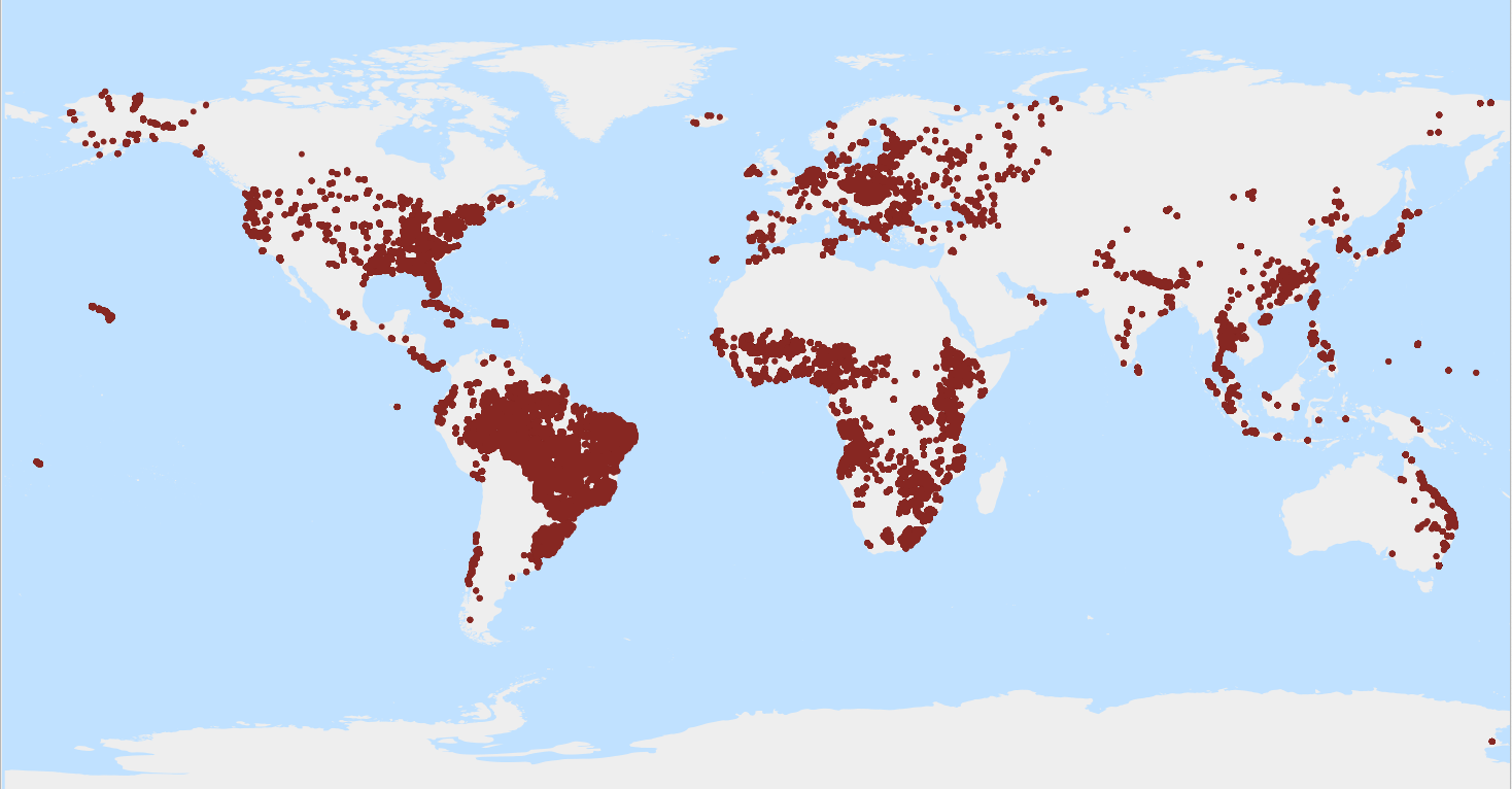
A measure of the acidity or alkalinity in soils, defined as the negative logarithm (base 10) of the activity of hydronium ions (H+) in a KCl solution, as specified in the analytical method descriptions. WoSIS_latest is a 'dynamic dataset' that contains the most recent complement of quality-assessed and standardised soil data served from WoSIS (ISRIC World Soil Information Service). The source data were shared by a wide range of data providers (see: https://www.isric.org/explore/wosis/wosis-contributing-institutions-and-experts). Being dynamic, the contents of 'wosis_latest' will change once new point data are acquired, cleansed and standardised, additional soil properties are considered, and/or when possible amendments are required. Static snapshots of 'wosis_latest' are released at irregular intervals for consistent citation purposes and to discuss methodological changes; the last snapshot is available at https://doi.org/10.5194/essd-16-4735-2024. For general information about WoSIS please see the FAQ-page at https://www.isric.org/explore/wosis/faq-wosis.
-
Soil pH x 10 in H2O at 6 standard depths (to convert to pH values divide by 10). Predictions were derived using a digital soil mapping approach based on Quantile Random Forest, drawing on a global compilation of soil profile data and environmental layers. To visualize these layers please use www.soilgrids.org.
-
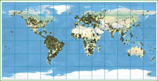
Version 3.1 of the ISRIC-WISE database (WISE3) was compiled from a wide range of soil profile data collected by many soil professionals worldwide. All profiles have been harmonized with respect to the original Legend (1974) and Revised Legend (1988) of FAO-Unesco. Thereby, the primary soil data ─ and any secondary data derived from them ─ can be linked using GIS to the spatial units of the digitized Soil Map of the World as well as more recent digital Soil and Terrain (SOTER) databases through the soil legend code. WISE3 holds selected attribute data for some 10,250 soil profiles, with some 47,800 horizons, from 149 countries. Individual profiles have been sampled, described, and analyzed according to methods and standards in use in the originating countries. There is no uniform set of properties for which all profiles have analytical data, generally because only selected measurements were planned during the original surveys. Methods used for laboratory determinations of specific soil properties vary between laboratories and over time; sometimes, results for the same property cannot be compared directly. WISE3 will inevitably include gaps, being a compilation of legacy soil data derived from traditional soil survey, which can be of a taxonomic, geographic, and soil analytical nature. As a result, the amount of data available for modelling is sometimes much less than expected. Adroit use of the data, however, will permit a wide range of agricultural and environmental applications at a global and continental scale (1:500 000 and broader). Preferred citation: Batjes NH 2009. Harmonized soil profile data for applications at global and continental scales: updates to the WISE database. Soil Use and Management 5:124–127, http://dx.doi.org/10.1111/j.1475-2743.2009.00202.x