 Stars4Water
Keyword
phytogeographic units
Type of resources
Available actions
Topics
Keywords
Contact for the resource
Provided by
Representation types
Update frequencies
status
Scale
From
1
-
1
/
1
-
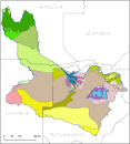
This vector layer delineates the phytogeographic units within the Okavango Basin. Source: Several (FAO, WCMC, Phytogeographic Chart of Angola). Irreconcilable adjustments between Namibia and Botswana. This dataset is part of the GIS Database for the Environment Protection and Sustainable Management of the Okavango River Basin project (EPSMO). Detailed information on the database can be found in the “GIS Database for the EPSMO Project†document produced by Luis Veríssimo (FAO consultant) in July 2009, and here available for download.