 Stars4Water
digital elevation model
Type of resources
Available actions
Topics
Keywords
Contact for the resource
Provided by
Representation types
Update frequencies
status
Scale
-
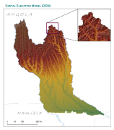
This raster layer represents the Digital Elevation Model (DEM) of the CORB-Contributing area, in the reference scale of 1/200 000. It was created by converting raw SRTM data into a finalized raster layer for the CORB-Contributing area with 90m pixel resolution. This dataset is part of the GIS Database for the Environment Protection and Sustainable Management of the Okavango River Basin project (EPSMO). Detailed information on the database can be found in the “GIS Database for the EPSMO Project†document produced by Luis Veríssimo (FAO consultant) in July 2009, and here available for download.
-
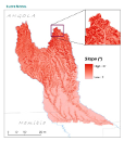
This raster layer represents the slope model of the CORB-Contributing area, in the reference scale of 1/200 000. The creation of this layer was achieved by interpolating the DTM raster layer. Units are organized by degrees. This dataset is part of the GIS Database for the Environment Protection and Sustainable Management of the Okavango River Basin project (EPSMO). Detailed information on the database can be found in the “GIS Database for the EPSMO Project†document produced by Luis Veríssimo (FAO consultant) in July 2009, and here available for download.