 Stars4Water
DEM
Type of resources
Available actions
Topics
Keywords
Contact for the resource
Provided by
Years
Representation types
Update frequencies
status
Scale
-
MERIT is a merger of existing DEMs (NASA SRTM3 DEM, JAXA AW3D DEM, Viewfinder Panoramas' DEM). With error removal especially aimed at geoscience applications which are terrain-dependent. Resolution is 90m.
-
The Copernicus DEM is a Digital Surface Model (DSM) that represents the surface of the Earth including buildings, infrastructure and vegetation. The Copernicus DEM is provided in 3 different instances: EEA-10, GLO-30 and GLO-90. Data were acquired through the TanDEM-X mission between 2011 and 2015. The datasets were made available for use in 2019 and will be maintained until 2026. Resolution is 10m for Europe and 30m globally.
-
The Shuttle Radar Topography Mission (SRTM, see Farr et al. 2007) digital elevation data is an international research effort that obtained digital elevation models on a near-global scale. This SRTM V3 product (SRTM Plus) is provided by NASA JPL at a resolution of 1 arc-second (approximately 30m).
-
ASTER GDEM was generated using stereo-pair images collected by the ASTER instrument onboard Terra. Resolution is 30m. ASTER GDEM coverage spans from 83 degrees north latitude to 83 degrees south, encompassing 99 percent of Earth's landmass.
-
The ALOS Global Digital Surface Model (AW3D30) is a global dataset generated from images collected using the Panchromatic Remote-sensing Instrument for Stereo Mapping (PRISM) aboard the Advanced Land Observing Satellite (ALOS) from 2006 to 2011. As described by the Japan Aerospace Exploration Agency: The Japan Aerospace Exploration Agency (JAXA) releases the global digital surface model (DSM) dataset with a horizontal resolution of approx. 30-meter mesh (1 arcsec) free of charge.
-
GTOPO30 is a global digital elevation model (DEM). It was derived from several raster and vector sources of topographic information. GTOPO30, completed in late 1996, was developed over a three year period through a collaborative effort led by staff at the U.S. Geological Survey's Center for Earth Resources Observation and Science (EROS).
-
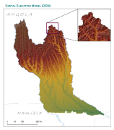
Digital Terrain Model within the Okavango Basin. Source: Data generated under the GIS EPSMO program (base:SRTM data). This dataset is part of the GIS Database for the Environment Protection and Sustainable Management of the Okavango River Basin project (EPSMO). Detailed information on the database can be found in the “GIS Database for the EPSMO Project†document produced by Luis Veríssimo (FAO consultant) in July 2009, and here available for download.
-
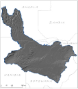
This raster layer represents the hill shade model within the Okavango Basin. Source: Data generated under the GIS EPSMO program (base:OB_DTM). This dataset is part of the GIS Database for the Environment Protection and Sustainable Management of the Okavango River Basin project (EPSMO). Detailed information on the database can be found in the “GIS Database for the EPSMO Project†document produced by Luis Veríssimo (FAO consultant) in July 2009, and here available for download.
-
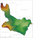
This raster layer represents the Digital Elevation Model (DEM) of the CORB-Contributing area, in the reference scale of 1/200 000. It was created by converting raw SRTM data into a finalized raster layer for the CORB-Contributing area with 90m pixel resolution. This dataset is part of the GIS Database for the Environment Protection and Sustainable Management of the Okavango River Basin project (EPSMO). Detailed information on the database can be found in the “GIS Database for the EPSMO Project†document produced by Luis Veríssimo (FAO consultant) in July 2009, and here available for download.