 Stars4Water
denominator
2000000
Type of resources
Available actions
Topics
Keywords
Contact for the resource
Provided by
Representation types
Update frequencies
status
Scale
From
1
-
1
/
1
-
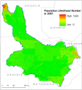
Population database compiled on a 30x30†lat/long grid, for the years: 1998, 2000 and 2007. within the Okavango Basin. Census counts (at sub-national level) were apportioned to each grid cell based on likelihood coefficients, which are based on proximity to roads, slope, land cover, nighttime lights, and other information.Source: Oak Ridge National Laboratory (ORNL). This dataset is part of the GIS Database for the Environment Protection and Sustainable Management of the Okavango River Basin project (EPSMO). Detailed information on the database can be found in the “GIS Database for the EPSMO Project†document produced by Luis Veríssimo (FAO consultant) in July 2009, and here available for download.