 Stars4Water
toponomy
Type of resources
Available actions
Topics
Keywords
Contact for the resource
Provided by
Representation types
Update frequencies
status
Scale
-

A set of 13 ortho-image maps was elaborated for the main settlements in the basin at the nominal scale of 1/5 000 (the coverage is constrained by the free availability of data). Source: Free of charge acquisition and pre processing under the GIS EPSMO program. This dataset is part of the GIS Database for the Environment Protection and Sustainable Management of the Okavango River Basin project (EPSMO). Detailed information on the database can be found in the “GIS Database for the EPSMO Project†document produced by Luis Veríssimo (FAO consultant) in July 2009, and here available for download.
-
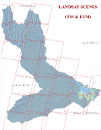
Partial coverage of band compositions data of Landsat MSS, Landsat TM and Landsat ETM, in the decadal intervals of 1972-87 (MSS), 1987-97 (TM), 1999-2008 (ETM). Source: Free of charge acquisition (Global Land Cover Facility) and pre processing under the GIS EPSMO program. This dataset is part of the GIS Database for the Environment Protection and Sustainable Management of the Okavango River Basin project (EPSMO). Detailed information on the database can be found in the “GIS Database for the EPSMO Project†document produced by Luis Veríssimo (FAO consultant) in July 2009, and here available for download.
-

Complete set of 16 medium scale topographic maps, that share geographical overlapping with the Okavango Basin. Source: Instituto de Geodesia e Cartografia de Angola (IGCA), Luanda. Original data georeferenced under the GIS EPSMO program. This dataset is part of the GIS Database for the Environment Protection and Sustainable Management of the Okavango River Basin project (EPSMO). Detailed information on the database can be found in the “GIS Database for the EPSMO Project†document produced by Luis Veríssimo (FAO consultant) in July 2009, and here available for download.
-

Toponomy Gazetteers within the Okavango River Basin. Source: DCW and GNS. This dataset is part of the GIS Database for the Environment Protection and Sustainable Management of the Okavango River Basin project (EPSMO). Detailed information on the database can be found in the “GIS Database for the EPSMO Project†document produced by Luis Veríssimo (FAO consultant) in July 2009, and here available for download.
-

Hydrographical related toponomy within Okavango River Basin. Source: Africa Water Resources Database (FAO). This dataset is part of the GIS Database for the Environment Protection and Sustainable Management of the Okavango River Basin project (EPSMO). Detailed information on the database can be found in the “GIS Database for the EPSMO Project†document produced by Luis Veríssimo (FAO consultant) in July 2009, and here available for download.
-

Complete set of 27 (500k) and 8 (200k) medium scale topographic maps, that share geographical overlapping with the Okavango Basin. Source: International Russian topo maps georeferenced under the GIS EPSMO program. This dataset is part of the GIS Database for the Environment Protection and Sustainable Management of the Okavango River Basin project (EPSMO). Detailed information on the database can be found in the “GIS Database for the EPSMO Project†document produced by Luis Veríssimo (FAO consultant) in July 2009, and here available for download.
-

Complete set of 23 medium scale topographic maps, that share geographical overlapping with the Okavango Basin. Source: Instituto de Geodesia e Cartografia de Angola (IGCA), Luanda. Original data georeferenced under the GIS EPSMO program. This dataset is part of the GIS Database for the Environment Protection and Sustainable Management of the Okavango River Basin project (EPSMO). Detailed information on the database can be found in the “GIS Database for the EPSMO Project†document produced by Luis Veríssimo (FAO consultant) in July 2009, and here available for download.