 Stars4Water
hydrogeology
Type of resources
Available actions
Topics
Keywords
Contact for the resource
Provided by
Formats
Representation types
Update frequencies
status
Scale
-
This map, compiled to support the analysis of SOLAW report concerning trends and current use of water use in agriculture, shows the percentage of irrigated area supplied by groundwater. Irrigation mainly relies on renewable freshwater resources, either surface water or groundwater. However, while the extent of irrigation and related water uses are reported in statistical databases or by model simulations, information on the source of irrigation water is still very rare. A recent global inventory undertaken by FAO and the University of Bonn reports that 113 million ha, or 38 percent of the total area equipped for irrigation of 301 million ha, is irrigated by groundwater (Siebert et al, 2010).
-
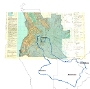
Geology and Hydrogeology Map of Angola, that shares geographical overlapping with the Okavango Basin. Source: Instituto de Geodesia e Cartografia de Angola (IGCA), Luanda. Original data georeferenced under the GIS EPSMO program. This dataset is part of the GIS Database for the Environment Protection and Sustainable Management of the Okavango River Basin project (EPSMO). Detailed information on the database can be found in the “GIS Database for the EPSMO Project†document produced by Luis Veríssimo (FAO consultant) in July 2009, and here available for download.