 Stars4Water
irrigation
Type of resources
Available actions
Topics
Keywords
Contact for the resource
Provided by
Years
Formats
Representation types
Update frequencies
status
Scale
-
The Food and Agriculture Organization of the United Nations (FAO) with the collaboration of the International Institute for Applied Systems Analysis (IIASA), has developed a system that enables rational land-use planning on the basis of an inventory of land resources and evaluation of biophysical limitations and potentials. This is referred to as the Agro-ecological Zones (AEZ) methodology.
-

The FGGD irrigated areas map is a global raster datalayer with a resolution of 5 arc-minutes. Each pixel in the map contains a value representing the percentage of the area equipped for irrigation. The data are a IIASA modification of FAO and University of Kessel (2002), Digital Global Map of Irrigated Areas v. 2.1. Please for the latest version refer to www.fao.org/ag/agl/aglw/aquastat/irrigationmap/index10.stm
-
This map represents the spatial distribution of land under irrigation which is affected by some degree of salinization. It was produced by combining FAO AQUASTAT country statistics regarding irrigated areas affected by salinization with spatial information on irrigated areas where precipitation is not sufficient to leach away salt residues that are built up in the soil due to irrigation. It was assumed that the risk of salinization of irrigated areas can occur only in areas with an Aridity Index lower than 0.65 (where the Aridity Index is defined as Yearly Precipitation divided by Yearly Reference Evapotranspiration).
-

This map provides a representation of levels of water scarcity by major hydrological basin, expressed in terms of the ratio between irrigation water that is consumed by plants through evapotranspiration and renewable fresh water resources. Contrarily to previous water scarcity maps, this map uses consumptive use of water rather than water withdrawal. Renewable fresh water resources as well as net irrigation water requirements in the river basin are calculated through a water balance model, with information regarding climate, soils and irrigated agriculture as input data. The legend distinguishes three classes: • Water scarcity in river basins where evapotranspiration due to irrigation is less than 10% of the total renewable water resources is classified as low; • Water scarcity in river basins where evapotranspiration due to irrigation is in between 10% and 20% of the total renewable water resources is classified as moderate; • Water scarcity in river basins where evapotranspiration due to irrigation is more than 20% of the total renewable water resources is classified as high.
-

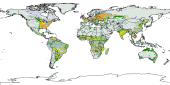
Global Map of Irrigation Areas - Version 5 Grid with percentage of area equipped for irrigation with a spatial resolution of 5 arc minutes or 0.083333 decimal degrees. This dataset is developed in the framework of the AQUASTAT Programme of the Land and Water Division of the Food and Agriculture Organization of the United Nations and the Rheinische Friedrich-Wilhems University, Germany. The map shows the amount of area equipped for irrigation around the year 2005 in percentage of the total area on a raster with a resolution of 5 minutes. Additional map layers show the percentage of the area equipped for irrigation that was actually used for irrigation and the percentages of the area equipped for irrigation that was irrigated with groundwater, surface water or non-conventional sources of water. In details, the following products have been released and made available for download: (A) Area equipped for irrigation expressed as percentage of total area: total=aei, surface water=aeisw, groundwater=aeigw, non-conventional sources of water=aeinc (ASCII-grid); (B) Area actually irrigated expressed as percentage of area equipped for irrigation (ASCII-grid); (C) Area equipped for irrigation expressed in hectares per cell (ASCII-grid); (D) Irrigated areas v.5 (ESRI shapefile); (E) High and low resolution images (PDF); (F) Quality Assessment (Excel) Due to the map generation method, the quality of the map can never be uniform. The overall quality of the map depends heavily on the individual quality of the data for the different countries.
-
Geo-referenced point database on dams in Africa.
-
This map, compiled to support the analysis of SOLAW report concerning trends and current use of water use in agriculture, shows the percentage of irrigated area supplied by groundwater. Irrigation mainly relies on renewable freshwater resources, either surface water or groundwater. However, while the extent of irrigation and related water uses are reported in statistical databases or by model simulations, information on the source of irrigation water is still very rare. A recent global inventory undertaken by FAO and the University of Bonn reports that 113 million ha, or 38 percent of the total area equipped for irrigation of 301 million ha, is irrigated by groundwater (Siebert et al, 2010).