 Stars4Water
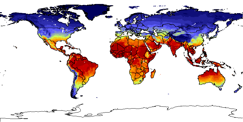
temperature
Type of resources
Available actions
Topics
Keywords
Contact for the resource
Provided by
Years
Formats
Representation types
Update frequencies
status
Scale
Resolution
-
The Food and Agriculture Organization of the United Nations (FAO) with the collaboration of the International Institute for Applied Systems Analysis (IIASA), has developed a system that enables rational land-use planning on the basis of an inventory of land resources and evaluation of biophysical limitations and potentials. This is referred to as the Agro-ecological Zones (AEZ) methodology.
-

A Decadal prediction data set of several atmospheric and oceanic variables is here presented for climate studies and comparisons. Predictions are performed one time every 5 years, with start date on Nov 1st, and integrated for twenty years. Each prediction is constituted of three ensemble members to have a minimal sample of the uncertainty on the initial conditions. The sampled variables are: The sampled variables are: - Specific Humidity (Q) - Relative Humidity (RH) - Temperature (T) - Zonal Wind (U) - Meridional Wind (V) - Surface temperature (surf_temp) - Zonal Wind at 10m (u10) - Meridional Wind at 10m (v10). The decadal predictions data are available for download on demand only. Please contact Andrea Borrelli at andrea.borrelli@cmcc.it to place your request. This data set has been produced in the framework of the "Climate change predictions in Sub-Saharan Africa: impacts and adaptations (ClimAfrica)" project, Work Package 2 (WP2). More information on ClimAfrica project is provided in the Supplemental Information section of this metadata.
-
The Food and Agriculture Organization of the United Nations (FAO) with the collaboration of the International Institute for Applied Systems Analysis (IIASA), has developed a system that enables rational land-use planning on the basis of an inventory of land resources and evaluation of biophysical limitations and potentials. This is referred to as the Agro-ecological Zones (AEZ) methodology.
-

A seasonal forecast dataset of several atmospheric and oceanic variables is here presented for climate studies and comparisons. Forecasts are performed four times a year, with start dates on Feb 1st, May 1st, Aug 1st, Nov 1st, and integrated for six months. Each forecast is constituted of nine ensemble members to sample the uncertainty on the initial conditions. The sampled variables are: - Specific Humidity (Q) - Relative Humidity (RH) - Temperature (T) - Zonal Wind (U) - Meridional Wind (V) - Surface temperature (surf_temp) - Zonal Wind at 10m (u10) - Meridional Wind at 10m (v10). The seasonal forecast datasets are available for download on demand only. Please contact Stefano Materia at stefano.materia@cmcc.it to place your request. This data set has been produced in the framework of the "Climate change predictions in Sub-Saharan Africa: impacts and adaptations (ClimAfrica)" project, Work Package 2 (WP2). More information on ClimAfrica project is provided in the Supplemental Information section of this metadata.
-
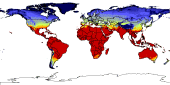
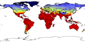
The thermal climates represent major latitudinal climatic zones. They were obtained through classifying monthly temperatures corrected to sea level (with an assumed lapse rate: 0.55°C/100m). The latitudinal thermal climates distinguished in global AEZ are the following: tropics, subtropics with summer rainfall, subtropics with winter rainfall, temperate, boreal and polar/arctic. The temperate and boreal belts have been further subdivided according to continentality into three classes, namely: oceanic, sub-continental and continental. Data derived from analysis over 37 years.
-
The Food and Agriculture Organization of the United Nations (FAO) with the collaboration of the International Institute for Applied Systems Analysis (IIASA), has developed a system that enables rational land-use planning on the basis of an inventory of land resources and evaluation of biophysical limitations and potentials. This is referred to as the Agro-ecological Zones (AEZ) methodology.
-

A set of 15 raster layers representing the monthly, annual, mean and average temperature for the Okavango Rive Basin. Source: Africa Water Resources Database (FAO). This dataset is part of the GIS Database for the Environment Protection and Sustainable Management of the Okavango River Basin project (EPSMO). Detailed information on the database can be found in the “GIS Database for the EPSMO Project†document produced by Luis Veríssimo (FAO consultant) in July 2009, and here available for download.
-
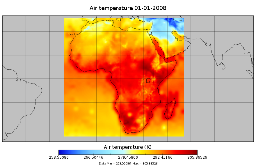
Bias-corrected and downscaled future climate meterological forcing data for Africa, for the period 1948-2099. This dataset is derived from the Global Meteorological Forcing Dataset for Land Surface Modeling, produced by the Princeton University [Department of Civil and Environmental Engineering]. The source data is a 150-yr (1948-2099) dataset of meteorological forcings for driving land surface models and other land modeling schemes. It is derived by bias correcting and downscaling WCRP CMIP3 climate model data for the 20th century and 21st century future climate projections. The dataset is bias-corrected and downscaled using the newly developed equidistant quantile matching method (Li et al., 2010) which better represents changes in the full distribution (not just the mean change). In addition to precipitation and temperature, radiation, humidity, pressure and windspeed are also downscaled. The downsclaing is based on the observational based global forcing dataset of Sheffield et al. (2006) also available from this website. The dataset is currently available at 1.0 degree, 3-hourly resolution globally for 1948-2008. Experimental versions include a 1901-2008 version, real-time updates, higher resolution versions at 0.25deg and 0.5deg and future climate projections based on bias-corrected climate model output. The data are currently available for one climate model (NCAR-PCM1) for the 20th century historical forcing (20C3M; 1948-2000) and one future climate scenario (SRES A2; 2001-2099). This work was supported by NSF Project 0629471 "Collaborative research: Understanding change in the climate and hydrology of the Arctic land region: Synthesizing the results of the ARCSS Fresh Water Initiative Projects". Variables description Tair: 2 m air temperature (K) PSurf: 2 m surface pressure (Pa) Qair: specific humidity (kg/kg) Wind: 10m wind speed (m/s) Precip: precipitation (mm) LWdown: Downwards long-wave radiation flux (W/m-2) LWnet: Net short-wave radiation flux (W/m-2) SWdown: Downwards short-wave radiation flux (average) (W/m-2) This data set has been produced for driving land surface models and other land modeling schemes, in the framework of the "Climate change predictions in Sub-Saharan Africa: impacts and adaptations (ClimAfrica)" project, Work Package 1 (WP1).