 Stars4Water
0.5 Degree
Type of resources
Available actions
Topics
Keywords
Contact for the resource
Provided by
Formats
Representation types
Update frequencies
status
Resolution
-
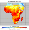
Bias Correction of ERA-interim meteorological forcing dataset for Africa, based on Piani et al. (2010) for the period 1979 - 2011. Variables description Tair: air temperature (K) Tmin: minimum air temperature (K) Tmax: maximum air temperature (K) PSurf: surface pressure (Pa) Qmean: specific humidity (kg/kg) Wind: wind speed (m/s) Precip: precipitation (mm) LWdown: Downwards long-wave radiation flux (W/m-2) SWdown: Downwards short-wave radiation flux (W/m-2). This data set has been produced in the framework of the "Climate change predictions in Sub-Saharan Africa: impacts and adaptations (ClimAfrica)" project, Work Package 1 (WP1). WP1 (Past climate variability) aimed to provide consolidated data to other WPs in ClimAfrica, and to analyze the interactions between climate variability, water availability and ecosystem productivity of Sub-Saharan Africa. Various data streams that diagnose the variability of the climate, in particular the water cycle, and the productivity of ecosystems in the past decades, have been collected, analyzed and synthesized. The data streams range from ground-based observations and satellite remote sensing to model simulations. More information on ClimAfrica project is provided in the Supplemental Information section of this metadata.
-
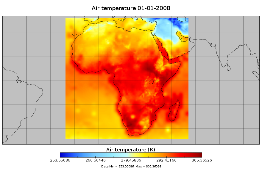
Bias-corrected and downscaled future climate meterological forcing data for Africa, for the period 1948-2099. This dataset is derived from the Global Meteorological Forcing Dataset for Land Surface Modeling, produced by the Princeton University [Department of Civil and Environmental Engineering]. The source data is a 150-yr (1948-2099) dataset of meteorological forcings for driving land surface models and other land modeling schemes. It is derived by bias correcting and downscaling WCRP CMIP3 climate model data for the 20th century and 21st century future climate projections. The dataset is bias-corrected and downscaled using the newly developed equidistant quantile matching method (Li et al., 2010) which better represents changes in the full distribution (not just the mean change). In addition to precipitation and temperature, radiation, humidity, pressure and windspeed are also downscaled. The downsclaing is based on the observational based global forcing dataset of Sheffield et al. (2006) also available from this website. The dataset is currently available at 1.0 degree, 3-hourly resolution globally for 1948-2008. Experimental versions include a 1901-2008 version, real-time updates, higher resolution versions at 0.25deg and 0.5deg and future climate projections based on bias-corrected climate model output. The data are currently available for one climate model (NCAR-PCM1) for the 20th century historical forcing (20C3M; 1948-2000) and one future climate scenario (SRES A2; 2001-2099). This work was supported by NSF Project 0629471 "Collaborative research: Understanding change in the climate and hydrology of the Arctic land region: Synthesizing the results of the ARCSS Fresh Water Initiative Projects". Variables description Tair: 2 m air temperature (K) PSurf: 2 m surface pressure (Pa) Qair: specific humidity (kg/kg) Wind: 10m wind speed (m/s) Precip: precipitation (mm) LWdown: Downwards long-wave radiation flux (W/m-2) LWnet: Net short-wave radiation flux (W/m-2) SWdown: Downwards short-wave radiation flux (average) (W/m-2) This data set has been produced for driving land surface models and other land modeling schemes, in the framework of the "Climate change predictions in Sub-Saharan Africa: impacts and adaptations (ClimAfrica)" project, Work Package 1 (WP1).
-

The datasets represent monthly Sensible and Latent Heat Flux at 0.5 degree spatial resolution from 1982 - 2010 over the African continent. For a detailed description of the data sets see: Jung, M. et all. (2011) Global patterns of land-atmosphere fluxes of carbon dioxide, latent heat, and sensible heat derived from eddy covariance, satellite, and meteorological observations. Journal of Geophysical Research - Biogeosciences, 116, doi:10.1029/2010JG001566. request by email. This data set has been produced in the framework of the "Climate change predictions in Sub-Saharan Africa: impacts and adaptations (ClimAfrica)" project, Work Package 1 (WP1). WP1 (Past climate variability) aimed to provide consolidated data to other WPs in ClimAfrica, and to analyze the interactions between climate variability, water availability and ecosystem productivity of Sub-Saharan Africa. Various data streams that diagnose the variability of the climate, in particular the water cycle, and the productivity of ecosystems in the past decades, have been collected, analyzed and synthesized. The data streams range from ground-based observations and satellite remote sensing to model simulations. More information on ClimAfrica project is provided in the Supplemental Information section of this metadata.
-
Dataset with information on fractions of different crop types /CFTs at different land cover fractions based on the Synergetic Land Cover Product (SYNMAP), at global scale and for the African continent. SYNMAP is an improved global land cover product with 48 classes at 1-km spatial resolution, reflecting global land covers around year 2000. It fuses different global land cover products, including, Global Land Cover Characterization Database (GLCC), GLC2000, and the 2001 MODIS land cover product, based on fuzzy agreement, which highlights individual strengths and weaknesses of mapping approaches. The overall advantage of the SYNMAP legend is that all classes are properly defined in terms of plant functional types mixtures, which can be remotely sensed and include the definitions of leaf type and longevity for each class with a tree component. This data set has been produced in the framework of the "Climate change predictions in Sub-Saharan Africa: impacts and adaptations (ClimAfrica)" project, Work Package 1 (WP1). WP1 (Past climate variability) aimed to provide consolidated data to other WPs in ClimAfrica, and to analyze the interactions between climate variability, water availability and ecosystem productivity of Sub-Saharan Africa. Various data streams that diagnose the variability of the climate, in particular the water cycle, and the productivity of ecosystems in the past decades, have been collected, analyzed and synthesized. The data streams range from ground-based observations and satellite remote sensing to model simulations. More information on ClimAfrica project is provided in the Supplemental Information section of this metadata.
-

A global daily database of satellite soil moisture based on harmonizing multiple passive (SSMR, SSM/I, TRMM, AMSRE, WINDSAT) and active (ERS, MATOP) satellite products. This data set has been produced in the framework of the "Climate change predictions in Sub-Saharan Africa: impacts and adaptations (ClimAfrica)" project, Work Package 1 (WP1). WP1 (Past climate variability) aimed to provide consolidated data to other WPs in ClimAfrica, and to analyze the interactions between climate variability, water availability and ecosystem productivity of Sub-Saharan Africa. Various data streams that diagnose the variability of the climate, in particular the water cycle, and the productivity of ecosystems in the past decades, have been collected, analyzed and synthesized. The data streams range from ground-based observations and satellite remote sensing to model simulations. More information on ClimAfrica project is provided in the Supplemental Information section of this metadata.
-

A consistent and harmonized product of satellite observed fraction of absorbed photosynthetically active radiation (FAPAR). FAPAR is a biophysical variable that indicates the state and health of the vegetation. This data set provides monthly FAPAR from 1982 until 2010 at global scale and for the African continent. The construction of the data set made use of existing products from AVHRR, SeaWiFS and MERIS satellite sensors. This data set has been produced in the framework of the "Climate change predictions in Sub-Saharan Africa: impacts and adaptations (ClimAfrica)" project, Work Package 1 (WP1). WP1 (Past climate variability) aimed to provide consolidated data to other WPs in ClimAfrica, and to analyze the interactions between climate variability, water availability and ecosystem productivity of Sub-Saharan Africa. Various data streams that diagnose the variability of the climate, in particular the water cycle, and the productivity of ecosystems in the past decades, have been collected, analyzed and synthesized. The data streams range from ground-based observations and satellite remote sensing to model simulations. More information on ClimAfrica project is provided in the Supplemental Information section of this metadata.