 Stars4Water
Population
Type of resources
Topics
Keywords
Contact for the resource
Provided by
Years
Representation types
Update frequencies
status
-
Global Human Settlement Layer, 2020 at 100 m resolution
-
Estimates of population density with age/sex breakdowns for each 100m x 100m grid square on the planet.
-
Population by country and projections until 2100
-

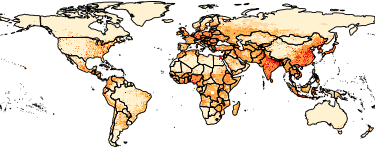
The Gridded Population of the World, Version 4 (GPWv4): Population Density, Revision 11 consists of estimates of human population density (number of persons per square kilometer) based on counts consistent with national censuses and population registers, for the years 2000, 2005, 2010, 2015, and 2020. A proportional allocation gridding algorithm, utilizing approximately 13.5 million national and sub-national administrative units, was used to assign population counts to 30 arc-second grid cells. The population density rasters were created by dividing the population count raster for a given target year by the land area raster. The data files were produced as global rasters at 30 arc-second (~1 km at the equator) resolution. To enable faster global processing, and in support of research communities, the 30 arc-second count data were aggregated to 2.5 arc-minute, 15 arc-minute, 30 arc-minute and 1 degree resolutions to produce density rasters at these resolutions.
-
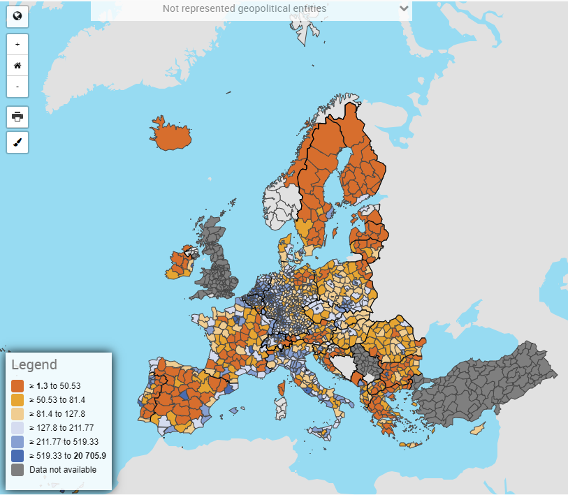
Member States send to Eurostat data on population on of 31 December of the reference year under Regulation 1260/2013 on European demographic statistics. The data are conventionally published by Eurostat as population on 1 January of the following year (reference year + 1). The aim is to collect annual mandatory and voluntary demographic data from the national statistical institutes. Mandatory data are those defined by the legislation listed under ‘6.1. Institutional mandate — legal acts and other agreements’. The completeness of the demographic data collected on a voluntary basis depends on the availability and completeness of information provided by the national statistical institutes. For more information on mandatory/voluntary data collection, see 6.1. Institutional mandate — legal acts and other agreements. The following statistics are available. Population on 1 January by sex and by: - single age and educational attainment / marital status / broad group of citizenship / broad group of country of birth; - five-year age group and citizenship / country of birth; - citizenship and broad group of country of birth / country of birth and broad group of citizenship; - broad age group and NUTS 3 (under regional data population folder); - single age and NUTS 2 (under regional data population folder); - five-year age group and NUTS 2 / NUTS 3 (under regional data population folder). Population structure statistics: median age of population, proportion of population by various age groups, old age dependency ratio.