 Stars4Water
FAO - GIS UNIT
Type of resources
Available actions
Topics
Keywords
Contact for the resource
Provided by
Formats
Representation types
Update frequencies
status
-
The FGGD CV of LGP map is a global raster datalayer with a resolution of 5 arc-minutes. Each pixel contains an average coefficient of variation of LGP for the pixel area over the period 1901-1966. The data are from FAO and IIASA, 2000, Global agro-ecological zones, as reported in FAO and IIASA, 2007, Mapping biophysical factors that influence agricultural production and rural vulnerability, by H. von Velthuizen et al.
-

The FGGD terrain slope constraints map is a global raster datalayer with a resolution of 5 arc-minutes. Each pixel contains a class value for the degree to which terrain slope constrains agricultural production potential in the pixel area. The data are from FAO and IIASA, 2000, Global agro-ecological zones, as reported in FAO and IIASA, 2007, Mapping biophysical factors that influence agricultural production and rural vulnerability, by H. von Velthuizen et al.
-

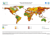
The FGGD irrigated areas map is a global raster datalayer with a resolution of 5 arc-minutes. Each pixel in the map contains a value representing the percentage of the area equipped for irrigation. The data are a IIASA modification of FAO and University of Kessel (2002), Digital Global Map of Irrigated Areas v. 2.1. Please for the latest version refer to www.fao.org/ag/agl/aglw/aquastat/irrigationmap/index10.stm
-
The FGGD severe environmental constraints map is a global raster datalayer with a resolution of 5 arc-minutes. Pixels with no severe environmental constraints contain a value of zero. Each other pixel contains a cumulative class value that shows which environmental constraint is binding in the pixel area. The data are from FAO and IIASA, 2000, Global agro-ecological zones, as reported in FAO and IIASA, 2007, Mapping biophysical factors that influence agricultural production and rural vulnerability, by H. von Velthuizen et al.
-
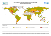
The FGGD terrain slope map is a global raster datalayer with a resolution of 5 arc-minutes. Each pixel contains a terrain slope class value for the pixel area. The data are from U.S. Geological Survey, 1993, GTOPO 30, as reported in FAO and IIASA, 2000, Global agro-ecological zones, and FAO and IIASA, 2007, Mapping biophysical factors that influence agricultural production and rural vulnerability, by H. von Velthuizen et al.
-
The FGGD CV of LGP map is a global raster datalayer with a resolution of 5 arc-minutes. Each pixel contains an average coefficient of variation of LGP for the pixel area over the period 1901-1996. The data are from FAO and IIASA, 2000, Global agro-ecological zones, as reported in FAO and IIASA, 2007, Mapping biophysical factors that influence agricultural production and rural vulnerability, by H. von Velthuizen et al.
-
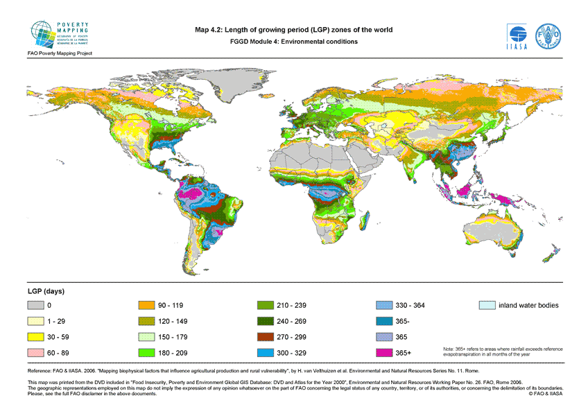
The FGGD LGP zone map is a global raster datalayer with a resolution of 5 arc-minutes. Each pixel contains a class value for the dominant LGP zone found in the pixel. The data are from FAO and IIASA, 2000, Global agro-ecological zones, as reported in FAO and IIASA, 2007, Mapping biophysical factors that influence agricultural production and rural vulnerability, by H. von Velthuizen et al.
-
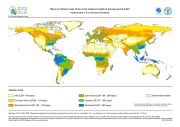
The FGGD climate constraints map is a global raster datalayer with a resolution of 5 arc-minutes. Each pixel contains a class value for the degree to which climate constrains agricultural production potential in the pixel area. The data are from FAO and IIASA, 2000, Global agro-ecological zones, as reported in FAO and IIASA, 2007, Mapping biophysical factors that influence agricultural production and rural vulnerability, by H. von Velthuizen et al.
-

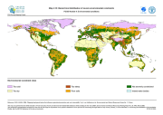
The FGGD soils map is a global raster datalayer with a resolution of 5 arc-minutes. Each pixel contains a class value for the major soil group found in the pixel area. The data are from FAO and IIASA, 2000, Global agro-ecological zones, as reported in FAO and IIASA, 2007, Mapping biophysical factors that influence agricultural production and rural vulnerability, by H. von Velthuizen et al.
-
The FGGD soil constraints map is a global raster datalayer with a resolution of 5 arc-minutes. Each pixel contains a class value for the degree to which soil characteristics constrain agricultural production potential in the pixel area. The data are from FAO and IIASA, 2000, Global agro-ecological zones, as reported in FAO and IIASA, 2007, Mapping biophysical factors that influence agricultural production and rural vulnerability, by H. von Velthuizen et al.