 Stars4Water
Inland waters
Type of resources
Available actions
Topics
Keywords
Contact for the resource
Provided by
Years
Formats
Representation types
Update frequencies
status
Scale
-
The Database for Hydrological Time Series of Inland Waters (DAHITI) provides hydrologial information on lakes, reservoirs, rivers, and wetlands derived from satellite data.
-
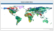
The raster dataset of easily available water has a spatial resolution of 5 * 5 arc minutes and is in geographic projection. Information with regard to available water was obtained from the "Derived Soil Properties" of the FAO-UNESCO Soil Map of the World which contains raster information on soil properties.
-
Geo-referenced point database on dams in Africa.
-
Climate change and growing pressure on natural resources are existential threats to both humanity and nature. These threats require ambitious responses. Increasing water risks have led to more attention on water-related threats. While demand for water has risen sharply in many regions of the world, as a result of population growth and economic expansion, climate change is expected to decrease water supply, alter the timing of water availability, and increase the severity of droughts and floods. These growing pressures on water resources undermine water security and contribute to conflict, migration, health crises, and food and energy insecurity across the world. Data on global water resources is essential for managing these growing risks and challenges. Global Water Watch, supported by Google.org and the Water, Peace, and Security Partnership, will provide free, globally accessible, near-real-time information on water. Deltares, World Resources Institute (WRI), and World Wildlife Fund (WWF) are partnering to create the data platform, which will house information on over 70,000 global reservoirs and major river systems, derived using satellite data, machine learning, and cloud computing. This data will help decision-makers respond to extreme weather events, manage growing risks of climate change, make societies more climate resilient, and preserve and restore our vital ecosystems and the many services they provide.
-
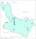
Location of fall, reservoirs, springs and other features within the Okavango River Basin. Source: Digital Chart of the World (DCW). This dataset is part of the GIS Database for the Environment Protection and Sustainable Management of the Okavango River Basin project (EPSMO). Detailed information on the database can be found in the “GIS Database for the EPSMO Project†document produced by Luis Veríssimo (FAO consultant) in July 2009, and here available for download.
-
This vector layer (point) represents the points at which stream segments intersect in the CORB-Contributing area, and can aid in the identified of locations for potential hydrological monitoring. This was created by an interpolation of all stream intersections in the Drainage Line layer. This dataset is part of the GIS Database for the Environment Protection and Sustainable Management of the Okavango River Basin project (EPSMO). Detailed information on the database can be found in the “GIS Database for the EPSMO Project†document produced by Luis Veríssimo (FAO consultant) in July 2009, and here available for download.
-
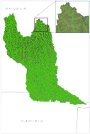
This vector layer (polygon) - reference scale 1/200 000 - also identifies the catchment area for each stream segment in the CORB-Contributing area. The value for each polygon corresponds to the value carried by the stream segment that drains that area, defined in the Stream Segmentation grid. Source: This layer was created by converting the Catchment Grid raster layer into vector format. This dataset is part of the GIS Database for the Environment Protection and Sustainable Management of the Okavango River Basin project (EPSMO). Detailed information on the database can be found in the “GIS Database for the EPSMO Project†document produced by Luis Veríssimo (FAO consultant) in July 2009, and here available for download.
-

Delineation of power lines in Namibia, that share geographical overlapping with the Okavango Basin. Source: Ministry of Agriculture, Water and Forestry of Namibia. This dataset is part of the GIS Database for the Environment Protection and Sustainable Management of the Okavango River Basin project (EPSMO). Detailed information on the database can be found in the “GIS Database for the EPSMO Project†document produced by Luis Veríssimo (FAO consultant) in July 2009, and here available for download.
-
This vector layer (line) – reference scale 1/200 000 – is a infered sub-surface drainage network model of the CORB-Contributing area. In the attributes table, each drainage line is linked to the micro catchment in which it resides. The creation of this layer was achieved by filtering the Drainage Network model with the Surface Drainage Network model. This dataset is part of the GIS Database for the Environment Protection and Sustainable Management of the Okavango River Basin project (EPSMO). Detailed information on the database can be found in the “GIS Database for the EPSMO Project†document produced by Luis Veríssimo (FAO consultant) in July 2009, and here available for download.
-
This raster layer (90m resolution) represents the flow accumulation in the CORB-Contributing area. This raster was created by interpolating the Flow Direction raster grid to discern the accumulated number of cells with flow direction upstream of a cell, for each cell in the input grid. This dataset is part of the GIS Database for the Environment Protection and Sustainable Management of the Okavango River Basin project (EPSMO). Detailed information on the database can be found in the “GIS Database for the EPSMO Project†document produced by Luis Veríssimo (FAO consultant) in July 2009, and here available for download.